Showing posts with label Planning. Show all posts

4.08.2024

Episode One: Plan G

You know how there is plan A and then plan B etc.? The last few weeks have been a lesson in always having a backup and/or being willing to go with the flow. I feel like I am currently on plan F or G of my trip already. The original plan had been to start from Grass Valley, CA and head over the Sierra toward Klamath Falls, OR, where I would meet up with some friends for about a week near Bend, OR before heading back to Klamath Falls to start north again. 

Things were looking pretty good for a while; the snow was melting and Punxsutawney Phil had said that spring was coming early, which I was a big fan of. However, about a week before I had planned on starting, there was a big snow storm in the Sierra and things started looking bleak for me. I told my Dad that his ski season was going to need to be cut short, but in the end, he got lucky. This was not a horrible thing; it just meant that my plan to try to stay on dirt paths for the bulk of my trip just went out the window, and instead of going over the hills, I would need to take the road around through the valley. However, this did not mean I did not need to go through the mountains still; I would just do it in a lower place instead. 

Country road, take me home...(table mountain in the distance)

In the next couple of days, I got to Red Bluff via backroads, and then cut east to head up and over the mountains. Well, this day it started raining, then snowing and then I actually hit snow at about 4,200 feet, which is a bit lower than expected. So I tried to plod through it for a while, but ultimately it was very hard and it was uphill and my feet were getting cold, so I decided to head back down the hill to regroup. I was going to try to hitchhike to the town of Burney, but nobody would pick me (a very wet person) and Bob (a very wet bike) up. Luckily, I found a feed store that was on the side of the highway and I went in and begged Sonny, the owner (we became good friends), if I could use his heater to warm up and asked him if he knew anyone with a truck who would be willing to give me a ride. 

After reviewing the weather in Burney and surrounds, I determined that the upcoming snow would make this journey a bit unpleasant and possibly dangerous, so in the end, I decided to go back to Redding, which is along highway 5 and wait for my friends there instead of in Klamath Falls. Luckily Sonny's friend was headed to town and he gave me a ride right to my motel! Thank goodness for friendly folks. After a week in Oregon, I was back in Redding, but ironically, though it had been nice for the last five days, it was set to snow again in the mountains! I decided to take a bus to Burney and start from there rather than trying to go up the snowy slopes of the highway. 

Yup, those are my tracks (and a bunny)

The pass I wanted to avoid

This turned out to be a wise decision. The highway (299) to Burney was uphill, windy and had very little shoulder and there were a couple of snowy passes. In the end, I skipped about 7 miles, but I am okay with that. I started off in Burney and headed east and then north again. However, lest you think it was easy, it was uphill, snowing part of the time, and in the 20s in the mornings! But I made it to Klamath Falls safely in the end. The weather is still supposed to be a bit hit and miss, but this week's lows are supposed to be in the 30s and highs in the 50s/60s so that is much better than 20s! I have spent a lot of time looking at weather, routes, and webcams lately, but hopefully things will become more (and stay more) spring-like after this. 

View of Mt. Lassen from highway 299

A few stats --> Dead animals seen on side of the road: snakes, squirrels, cat, deer, vole, birds, lots of unidentified bones. I have also seen lots of cans (but not as many as in Washington), cigarette packets, and beer bottles. Good things I've seen: many farms/ranches/live animals including goats, donkeys, ponies, horses, sheep, ducks, geese, hawks, unidentified birds, dogs & cats, many sunrises, many empty roads, fun small towns.

Now the fun part, the Q&A! If you haven't gone and asked any questions yet, you can do it here. Don't be shy! It can even be anonymous if you want it to! I thought I would answer a few in each post, except for some of Engie's questions, for which the answers will likely be an entire post! This time, I will answer a few logistic questions that I have recently been asked. 

Where do you sleep? (Michelle and various other friends) - I am doing a mix of wild camping, established camping, motels and staying with friends. Most of this will not be planned in advance, as I will not really know how fast or how far I will go each day, but my expectation is that I will likely try to have a warm bed and a shower about once a week. If it rains or snows on me a lot, this number may increase. [edited to add: given the snowy conditions, I have so far stayed in a motel 4 nights and wild camped 2 nights, but I am hoping to do a lot more camping over the next week.]

Wild camping in Modoc County, temps around 40

What do you eat? (Michelle and various other friends) - I carry enough food to get me to the next town, which will likely mostly be only a day or two's worth of food. However, there will be sections where I will need to carry several days worth of food or several liters worth of water. What I carry will be similar to backpacking food, like rice, beans and oatmeal, but I will also be able to carry some heavier things or fresher items like peanut butter, bagged salad and fruit/veggies. I will also stop in towns and eat real food from time to time! My favorite grocery store foods in town are ice cream, cheese and meat, but I will also be splurging on an omelet or a hamburger sometimes. I also do carry a stove and so I can have hot food like instant rice, oatmeal and coffee. 

Typical snack food

Coffee maker (aka the stove)

Where do you use the bathroom? (My friend K's 10 year old daughter L) - This really depends on where I am. The first few days I was in small towns or rural roads. If there is no traffic and/or I can hide, I usually just pee in the bushes. If I am in a town, I may use a park restroom or a gas station restroom, but I don't really like leaving my bike out too long. If I am camping, I will go in the bushes. If I am in a motel, I will use a toilet! 

Will I carry a weapon? (My aunt and my friend G) - Not this time. I am going to leave my Glock at home, but will likely get bear spray when I am closer to or am in Canada. 

Progress report: 352 mi / 563 km | 7 days | 42 hours (6 per day) | gummy bears eaten: 76

How was your week last week? Did you get any snow? Is it cold where you are? What do you do to warm up when you are cold? 

5.29.2023

Great Divide Trail: Logistics, Gear & Planning

Happy Memorial Day! This weekend kicks off the "official" backpacking season for me each year, so I thought I would finally post about the two week trip that I took to Oh Canada to hike the Great Divide Trail (GDT)! Hopefully you are off enjoying the extra day off of work and the sunshine today (and are reading this post on Tuesday)! 

Healy Pass - Banff NP

Canada's Great Divide Trail is a 1,123 km (702 mile) trail that follows the Great Divide between Kawka Provincial Park in the North to Waterton Lakes National Park in the south. If you are a Continental Divide Trail (CDT) hiker in the US, you can actually just keep going north if you wanted, following the GTD the rest of the way up to Kawka PP.  It flip flops between Alberta and British Columbia and goes through several different national and provincial parks and wilderness areas. 

It is made up of several trails linked together and some are very well maintained (Banff Mountain National Park), some of them are washed out and some of them are nearly non-existent and require route-finding (Don Getty Wildland Provincial Park). Some of the trail goes through places with more access to roads and/or people (Banff, Jasper etc.) bus some places are downright remote. In fact, if you are a NOBO hiker, when you arrive to Kawka, you have to hike out about 75 km (47 mi) on a forest service road to get back to a highway. You can find information about this and a lot more on the GTD website

The Route: I had been hiking in Yolo, Kootenay, Jasper and Banff before and had found the scenery stunning, so in 2018, I decided that I wanted to see more. However, I was not going to be able to cover it all in a two week vacation. I really wanted to see the four parks I mentioned again, but logistically, I felt it was easier to either pick a more southern section, therefore skipping Jasper, or pick a more northern one, therefore missing some of the Provincial Parks I had not been to. 

I decided to do a NOBO section hike of sections B, C and D which would be a 500 km (312 mi) stretch starting in Coleman and ending in Saskatchewan River Crossing. This would mean hiking about 25 miles per day. If needed, I could skip section C and bail out one road crossing before that at Field, which would be 385 km (247 mi) stretch and about 20 miles per day. I would start in Coleman since I could easily get a bus from Calgary, and hope that at the end I would not have to wait around for two days for a bus back. 

I used Gaia to map out my estimated miles per day and then exported the routes to the Offline Maps app. I also bought the GDT app for my phone so I would have a couple of different options for navigation. I won't lie, I did not figure out until two thirds through my trip that it's interactive and people could make notes in the app, which would have been helpful at the beginning, which was more rugged and had more route-finding. 

The Plan/Logistics: To hike the trail, you need to buy a Parks Canada National Pass, which covers entry into all the parks. I bought mine in advance and had it sent to my house. Camping is a little confusing as there are several different organizations and parks you have to deal with regarding passes and permits. You may need to book campsites in advance for many of the national parks and some provincial parks; this pdf list of all of the sites and whether or not they need to be booked was very helpful. When I went, they were not all online, but it looks like more are now; you can find the online booking tool here

I got a flight to Calgary from San Francisco, which after spending nearly 24 hours traveling to my mountain destinations in Europe, felt so short and easy! From Calgary, I took a Greyhound bus to Coleman. There was only one bus per day and it left Calgary around 10:00 pm, arriving in Coleman around 4:00 am. I flew in around 10:00 am, which left me with some time to kill, but I spent it having my last hamburger and beer, and buying fuel and bear spray since I could not fly with either of those. 

A quick note about Canadians and bear spray: I had to purchase bear spray and register it, as it could technically be used as a weapon. I was told that there was a serial number on the can and if I left it at a random trailhead and someone used it as a weapon, I would be liable. Wow. I am not sure what they expect foreigners to do with their (hopefully) unused bear spray. (Note: apparently you can rent it in Banff, but I did not find a place to do so in Calgary). After eating and shopping, I killed time reading and charging my electronics at a coffee shop before boarding my bus to Coleman. 

I arrived at Coleman around 4:00 am and was dropped off at the 7-11 in the dark on the side of the highway. I then had to walk a couple of miles on the highway to get to the trail. It was a bit of an odd start; I was very happy when I veered off the highway and onto the trail, although then you walk on ATV roads for the next maybe 20 or 30 miles, so it was not exactly what I had expected.

Once I had finished, I took a series of local busses and the Greyhound back to Calgary. The bus system in Canada was just okay; it definitely was not as good as the transport in Europe, and is probably more on par with some of the options in the US. For example, both the bus to Coleman and the one back to Calgary were just once a day and they were at very strange times. Also, as it is in the US, there were some interesting characters riding the bus, whereas in Europe everyone rides the bus, not just the people who do not have a car. 

The Big Three: I took my Big Agnes Fishhook UL1 Tent (one man - 47 oz.) on this trip. I used the Hyperlite 2400 Southwest Backpack (28.6 oz.) and Western Mountaineering Ultralite 20 degree sleeping bag (29 oz.). For my sleeping pad I had the Therm-a-Rest NeoAir Xlite short size (8 oz.) that had popped on my Kungsleden trip. I patched it up with the kit that comes with it, but it still slowly deflated throughout the night, so I was constantly blowing it up. My big three weighed about 7 pounds.

Base Pack Weight: My base pack weight was about 18 pounds, excluding clothing worn and including an extra dry and clean outfit for after the trail. You can see my LighterPack list for this trip here

Clothing: For weather, this trip ran the gamut. I experienced the following: baking in the sun, below freezing temperatures, snow and rain. I brought my normal list of layers: REI button down shirt, short sleeved shirt, Mountain Hardware ghost whisperer puffy jacket, Montbell rain jacket & REI rain pants. I also brought a buff, a windbreaker, gloves, beanie and tights just in case, and I used them all! I don't want to have a spoiler alert for my trip report, but after this trip, I did a lot of research about snow camping and waterproof gear.  

Food: After my Kungsleden trip, I decided that when I am hiking long days, I prefer to have a hot meal in the morning and am fine with a cold one in the evening. This saves on gas and time. However, I do love a warm cup of coffee, especially when it's cold. My plan was to have coffee and dinner for breakfast, which consisted of beans and rice, ramen and a couscous medley. For dinner, I would have cold muesli with fruit and powdered milk. This also allowed me to eat dinner easily on the go as well as not eating in my camp at night due to the presence of bears. 

I carried all of my food in two drybags, which I hung each night. However, this is more easily said than done, as some forests were made of only pine trees which did not have limbs long enough or high enough to hang a bag from. There were some nights that I had to hang the food as high as I could in two separate spots 100 feet away from my camp and pray for the best. 

Water: This was the bane of my existence. I carried the Sawyer mini and the 1 liter squeeze bag that comes with it as well as a one liter clean water container. Finding water was no issue at all, and I did not really need to carry more than a liter or so at a time most of the time. However, I popped the squeeze bag somewhere around day 4 or 5 and duct taped it up, but it required a bit of jerry rigging to make it work. Aside from that, filtering is my least favorite thing to do and I felt that I was constantly filtering on this trip. Spoiler alert, I have since fixed this problem with two magical items, the CNOC squeeze bag and gravity filtering! 

Total Pack Weight: Including two liters of water, about 20 pounds (13 days worth) of food, a medium fuel container and bear spray, my pack weighed about 40 pounds. Let me tell you, I was happy to eat my way toward a lighter pack on this trip! 

The Verdict: As I mentioned above, after this trip I dialed in my water filtration system a lot, which has made me a much happier camper. I also invested in some wet/cold weather items, as I got pretty wet and cold in good ol' Canada. Other than that, I was very happy with my set up. I definitely want to go back and hike more sections of this trail and maybe even revisit a few places, such as Mt. Assiniboine, which was very foggy on the day that I was there. I would say that my pack is quickly becoming my favorite piece of gear as it is lightweight, comfortable and mostly waterproof! 

More Information: GDT website

If you have any questions, let me know! Otherwise, happy hiking! 

Have you ever been to Canada? Have you ever ridden the Greyhound (or other long distance transport) in the US or Canada (and what did you think)? What did you do for the long weekend this weekend? 

11.23.2022

Emigrant Wilderness: Logistics, Gear & Planning

At the end of last month, my friend Dr. G (trail name Bugsy) and I decided to try to get one more trip to the Sierra before the snow flurries started to fly. And boy did we get lucky, as it started snowing the Tuesday after we got back and there have been several storms since.

The Emigrant Wilderness is a pretty small wilderness and is only about 25 miles long and 15 miles wide. However, don't let the size fool you! It is full of granite outcroppings and glacier scoured landscapes. It is also a great place to cut your teeth on cross country travel, as it is not too brushy in most places, so your "bushwhacking" is more like rock climbing than anything else.


The Plan/Logistics: When it had not snowed yet and Bugsy and I realized that we both had the weekend free, we kind of made a last minute decision to take a couple of days and get out one last time. Therefore, this was not the most well thought out or the most complicated plan; Emigrant Wilderness is about 2.5 hours away from the Bay Area if there is no traffic, so we decide that instead of sitting in the horror that is Friday traffic, we would start bright and early on Saturday. We left around 5 am and after two coffee/bathroom stops and a stop to get the (self issued) permit, we were on the trail by 7:50 am. Please note that if the ranger station is open (8:30 am - 4 pm on Saturday, 9 am - 4 pm all other days), you will have to get a permit from the ranger. They do not issue permits online. Permit info here.

The Route: we had a few options, but one of the things I wanted to try was a cross country route between Buck Creek and Huckleberry Lake, so we decided to give it a shot. I mapped it out on Gaia, but of course if there is no trail, you have to just estimate where you will go and it ended up being about 4 more miles than we had expected. That made what was planned to be about a 35 mile loop into about a 39 mile loop. Oops! We started from the Crabtree Trailhead, which is about 8 miles outside of Pinecrest Lake, and did a counter clockwise "loop" towards Huckleberry Lake. We ended up camping at Cherry Creek instead.

The Big Three: I have been using the same big three for a while and am loving them (Big Agnes Tiger Wall UL2 (46 oz. with footprint), Western Mountaineering Ultralite 20 degree sleeping bag (29 oz.), Hyperlite 2400 Southwest Backpack (28.6 oz.), and the Therm-a-Rest NeoAir Xlite regular size (12 oz.). However, on this trip, Bugsy brought his tent because it has a bigger floor plan than mine (Big Agnes Copper Spur 2), so my big three was only two! I also carried a silk liner, since we had gotten reports that it could get down into the mid twenties at night and my sleeping bag is not warm under about 30 degrees, despite the 20 degree rating. My big "two" weighed about 4.5 pounds.

Base Pack Weight: I did not weigh my base pack for the trip, but based on my LighterPack list and experience from other trips, I would say it was about 17 lbs.

Clothing: I brought everything from my normal list and did not bring any of the heavier winter gear or traction. My normal kit includes a beanie, gloves, extra socks & underwear, rain jacket and pants and a puffy, and the forecast was clear skies, so I did not feel that I would need the extra heavy gear for this trip. However, I did bring an older REI rain jacket rather than my ultralight Montbell, so I probably added a pound of extra weight by carrying that.

Food: This was a huge difference from our normal trips. Firstly, we usually share dinner duties; if we are going for 6 days, we will each make and carry three meals for two people. However, this time we each did our own thing since we didn't have to skimp to save weight. We brought lots of heavy stuff! For dinner, I brought noodles, salmon packets, fresh mushrooms, hard boiled eggs and miso paste. For snacks I brought a whole salami, cheese, cucumbers, nuts and blueberries! For breakfast I had hard boiled eggs and coffee. Not only could we afford to carry heavier food, but I didn't mind if I didn't use it, and we had built in refrigeration so we could carry whatever we wanted. It was divine.

Water: I used my new BeFree 1 liter filter bottle and carried an extra Platypus 1 liter bottle with a 2 liter Platypus for extreme emergencies/backup. I am glad I had the backup bottles as we went through some really dry stretches and crossed dry creeks that I had never seen dry before. However, we did camp near a lake so we really did not need to carry more than 1 - 2 liters at a time in the end.

Total Pack Weight: Including two liters of water, the bear can, one day of food and one fuel cannister (and the heavy rain jacket!), my pack weighed 25 lbs.

The Verdict: I really liked just going for one overnight as it really provides a lot of flexibility with food, which tends to be one of my most heavy items. It also is a great chance to test out items that you would not normally want to lug around for a week.  I could have lived without my rain pants and I am very glad that I added the silk liner, as I slept warm but not so warm that I would have been happy without it.

More Information: You can find information about the wilderness at the Stanislaus National Forest website. Stay tuned for the Trip Report!

For fun...here is what the same area looks like now! 

Highway 108 (source)

Have you been to the Emigrant Wilderness? What is your one backpacking item you cannot live without?

3.17.2022

Kungsleden (The King's Trail): Logistics, Gear and Planning

Kungsleden Trail, Sweden -- September 4 - 14, 2017
12 day hike -- 275 miles
Trip Report can be found here
Some of my favorite gear can be found here.

The Plan: How did I pick this trip? I did some research based on shorter long distance hikes. I wanted to go internationally, and needed it to be warm enough in the month of September for a two week trip. Obviously there are a ton of different websites and opinions, but many of the ones I found had the Kungsleden as one of the good ones. I wanted to be able to "wild camp," aka not have to stay in a designated camping area or hut. Surprisingly to me, since we can do this pretty much everywhere in California (and Canada and many of the other US states), Europe generally does not allow this. 

I also needed something that I could do in about 14 days. Most reports of the Kungsleden said it would take about a month. However, since the trail was about 450 km or 275 miles, I figured I could do it in less than that. I am comfortable hiking 20 - 30 miles per day and figured that if I hiked 20 miles for 14 days, or 23 miles for 12 days, I could get it done in time. The cherry on top was this woman's trip report, which showed that she had easily done it in 13 days. If she can do it, I can do it, I thought. What I did not factor in was that my original flight from the US to Sweden got canceled which pushed everything back one day. I also did not fully grasp the time that would be needed for the many lake crossings. 

The Logistics: Getting to/from the Stockholm airport to my hotel was fairly easy; I took a bus from the airport to downtown and then walked from the bus stop to my hotel, which took about five minutes. 

The logistics surrounding the hike were a little tough, as I had to fly to Stockholm and then take a puddle jumper flight from there to Kiruna, which only left once per day around noon. From there, I had to take a bus from the airport to downtown Kiruna, where I picked up a longer distance bus to Abisko, where the trail started. Alternatively, I believe there was a train that went from downtown Kiruna to Abisko, but that was a little later or longer than the bus; I cannot remember exactly. 

Since I was flying, I could not bring fuel on the plane. There have been other reports that you cannot bring trekking poles or tent poles and you definitely cannot carry a knife, so I checked my bag and carried on a small duffel with a few toiletries and my book which I planned to leave at my hotel in Stockholm. I wore an outfit on the plane that I did not plan on taking hiking with me and I also left in my hotel. That meant that I had to stay in the same hotel on the way in and out and also decreased my hiking time a little bit, but I did not want to carry all of my stuff with me while hiking; I thought it was worth having a dry, comfortable, non hiking outfit (and book etc.) for afterward. 

Once in Abisko, it was required that everyone obtain a permit. There were not quotas for the permit, but you do have to pay for it and there is a little store that you have to go to near the trailhead to get it. I also bought fuel at this store and weighed my full bag before setting off. 

After I was done, from the southern terminus of Hemavan, I could fly, or I would have to take a local bus to Umea, which is on the Eastern coast and has overnight busses back to Stockholm, which took about 12 hours. Not knowing exactly how long the total hike would take, I did not want to book this leg in advance,. I knew the logistics of the bus travel at the end could add a couple of days, so my plan was to try to hike a little bit faster than 20 miles per day just in case. Also knowing that the flight at the end was also only once per day and that there was a chance I would miss it, I wanted to give myself extra time for that as well. 

Since I ended getting off trail a little early, I ended up having to take a bus from Ammarnäs to Sorsele and then another to Lycksele and then yet another to Umea. Once in Umea, I had to wait for the overnight bus, which left around 11 pm. I did not realize that most people reserve their seat and so when I got on the bus the conductor said it was full and I almost cried. Luckily he found one spot for me, but I may have had to wait until the next day if there was not a seat. Alternatively there were flights and trains, but I was at the bus station so it would have been a little extra travel to do that instead. This bus dropped me in the same downtown bus station that I had gone into from the airport originally, so I could just walk to my hotel. 

As I mentioned in my trip report, the trail did have huts that you could stay in for part of the time. The trail was split into thirds with the north third being more developed with huts and the middle third being very rugged and the southern third being a little more developed again, but more rustic than the north, which is the most popular area. However, I brought my tent and sleeping bag and planned to use them the entire time. I also brought all of my own food, although there were reports that you could buy some things at the huts. However, since I was also going a little late in the season, I had read that some of the huts could already be closed down for the winter. I did not notice this for the northern third, but it could have been the case on the southern third. 

The Route: I knew that this trail was very well marked and also there were not really any "mountain passes" like I was used to, so you can see for miles where you are going at times. I used a mixture of Gaia GPS app and Offline Maps app for maps. Usually I plan my route with Gaia when I am in service and then export it to Offline Maps. As long as you save the map area that you are going to be in, you can use this any time, anywhere. It has topography, roads and trails on it and it has been very handy over the years. 

The Big Three: I brought the following: Big Agnes Fishhook UL1 Tent (47 oz.) (no longer available; I now use the Big Agnes Tiger Wall UL2), Western Mountaineering Ultralite 20 degree sleeping bag (29 oz.)Hyperlite 2400 Southwest Backpack (28.6 oz.), and the Therm-a-Rest NeoAir Xlite Small size (8 oz.). Total weight of my big three: 112 oz. or about 7 lbs. 

The Clothing: I used my basic late fall/winter hiking kit, which consists of the following clothing: Capri pants, rain pants, short sleeved running shirt, long sleeved running shirt, rain jacket, puffy jacket, Saucony running shoes, two pairs of socks, hat, sports bra, two pairs of underwear, buff and flip flops for camp. I also carried the following dry outfit, which I planned on not wearing until the hike was over: Northface tights, socks, underwear, long sleeve shirt. 

The Other Stuff: For electronics, I carried my phone, a waterproof Panasonic camera, Ankur 20 milliamp charger, charging cords, Garmin watch, kindle and headlamp. I also had to bring toiletries, kitchen items (pot, pan, spoon, bowl, fuel, matches etc.), first aid, dry bags and other utility items (knife, rope, compass, trash bag, whistle etc.). 

Base Pack Weight: 18 pounds. 

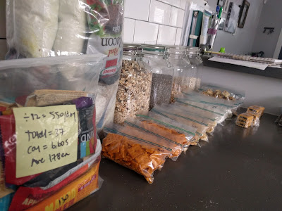
The Food: I packed 12 days worth of food in total. I had all of my food already packed before I left home, as I did not want to worry about trying to resupply. I could always buy something extra if I wanted but I did not want to rely on that. I did not put my food in a bear canister and I did not plan to hang it. From what I read, there are bears in Sweden but encounters with them are very rare.  

My meals were fairly basic: I brought muesli with dried fruit and powdered milk for breakfast, which I planned to eat cold as I did not plan on resupplying my fuel and did not want to waste it. I was going to have coffee in the morning as well and was debating between hot and cold coffee. For lunch/snacks, I had a variety of things: yogurt covered pretzels, cheeze-its, peanuts, wasabi rice snacks, gummy snacks, peanut butter, trail mix, chocolate and protein bars. For dinner, I had Knorr pasta sides and beans and rice (this was and still is one of my standby meals). I did find a few days into the hike that I preferred my hot meal in the morning, so I started eating my dinner for breakfast and then having my muesli in the evening instead. 

I planned all of my calories before leaving and tried to plan for about 3500 per day. 


The H2O: I decided not to filter water and so only brought a one liter soft flask. I know this may be controversial, but from what I read it was not necessary. On one hand, it felt a little bit like going braless in public, but damn, it is so nice not to have to rely on filtering water all the time. It was freeing and meant that I only carried about a liter of water at a time, if that. 

Total Pack Weight: 37 pounds; the fuel and 12 days of food added basically 20 pounds to my load, which comes out to about a pound and a half of food per day. Luckily I didn't have to carry too much water! 

The Verdict: I am still loving my new gear, which I bought in early 2017 and used for the Wind River High Route. I carried about 10 more pounds than I did for the Wind River trip due to carrying the tent and a lot more food, but the pack still felt good. My sleeping bag kept me warm the whole time; obviously having a hole in my sleeping pad was not ideal. I definitely need a new system for all day rain as being wet and cold all day and sometimes through the night was not fun at all. 

A couple of things I would probably leave behind: My rain pants have seen their last days. These were ones I think I bought in the Philippines or Malaysia before hiking Mt. Kinabalu and they are a prime example of getting what you pay for. I need to invest in some that will actually keep me dry. I also brought a variety of snacks so that I would not get bored with my food, but I think I will just pick one or two of my favorites and/or the highest calorie ones and bring only a couple of choices next time. I definitely will not be including the melted blog of yogurt covered pretzel or the cheeze-it dust on this list. I also need to consider the shape of the items as some of them take up a lot room, so even if they are calorie dense, it is not as compact. 

A couple of things I might bring more of: I do like having hot coffee in the morning, if only as something to wrap my hands around before getting out of the tent into the cold, but I am not sure that I really need a hot meal. I think I could just bring more cold meals and save the time and effort of cooking. However, I think it is weather dependent, as I really do like a hot meal when it's really cold. I also do bring duct tape and a patch kit with me, but may need to invest in a few more repair items for the next trip. 

A couple of things I could not live without: See above! If I had not had duct tape with me, I would have had to sleep pretty much right on the ground after my sleeping pad got a hole. This was a lifesaver. It is easy enough to wrap around a trekking pole or a pencil and not even notice that you are carrying it and it sure comes in handy in a pinch! I also wore my rain pants 90% of the time on this hike. Although they are definitely not water proof, they did really help to keep the wind off of my legs and were priceless as an extra lightweight layer. Lastly, it was worth carrying the one dry change of clothes, despite the weight. After I got off trail, I had to take a series of buses to Stockholm (roughly a 24 hour trip from the end of the trail) and I would have been miserable in my wet hiking clothes. 

Are you a planner or do you just like to get up and go? What is one thing you could not live without when you travel? 

5.10.2013

Beer, Bikes and Busted Plans

{1} Why is it the week I decide to avoid sugar is the week that...I go out to dinner with my brother (which I only do about once a month), my friend's band is playing at a bar in my neighborhood, the ladies at work get together for happy hour, I am meeting a friend for a birthday dinner (two times eating out in one week!) and it's Mother's Day Brunch. When it rain's it pours, I guess.

{2} I went to see my friend's band on Wednesday and I rode my bike to the show. I am no bike expert, let me tell you. I barely know how to shift gears. Why does it always seem like every time I shift it gets harder? It never gets easier, I swear! Downshift, upshift...either way, it keeps getting harder. So I was riding the bike back home when I shifted and the chain fell off and got tangled up in the round thingy, which I googled, and found out it's called a cassette. I had to walk the rest of the way home.

{3} I was supposed to go to a music festival this weekend, but then my friend flaked out so we decided to sell our tickets and I made other plans with other people for the weekend. But then nobody wanted to buy them and I've been placing ads on Craigslist and dealing with a lot of flaky people and I am getting annoyed. This is why I don't change plans; it gets aggravating, scrambling around at the last minute trying to coordinate things, changing plans with everybody, not knowing what your actual plans will be, and losing money on top of all of it.

{4} My roommate got a dog. That's really all I have to say about that. No really, it's cute; it's a puppy; it pooped on the floor today. What else is there to say, really?

{5} I have this race tomorrow with Broski. It will be his first 30k and his longest run ever! By the way, I think he's finally come to terms with the fact that the trail "half marathons" are not always 13.1 miles.


What's going on in your life? Any fun plans for the weekend? Do you know anything about bikes?

7.28.2007

Southern Hemisphere is Almost Here!

The Players and The Possibilities: Me.CK.Doyle.S.M.G-man.Danielle.Pete.K


Except for Pete and K, I have met all of these folks while working around the country doing disaster assistance. First of all, do do this job you already have to be a bit of a wanderer - able to live away from home for long periods at a time, to be without your friends and family. Because of this, we make new friends and aquire a new family. The folks above are prime examples of that. In the past few years, we have all traveled together, visited each other and kept in touch, although most of us don't work together anymore (most people had to eventually go back to their "real" jobs).

The Possible Route:

Only a skeleton plan so far, the general idea is to hit up about 8-10 countries in about as many months. Leaving sometime at the end of 2007, our trip will probably begin in either Chile or Argentina and we will work our way north as the weather in the Southern Hemisphere gets colder in the south and warmer in the north.

When it all begins:

We will leave right after Christmas and probably (as we know it so far) start in Chile, going to see Patagonia in the only few months it is warm enought to bear. From there the possibilities are endless!!!

Planning is fun, right?!!!

We have been talking about this for such a long time but in all honesty, aside from a few key places, events and attractions, we really don't know what we want to do. We will rely half on the guidebook and half on the whim of the day... that is what makes it so exiciting (and scary, but in a GOOD way!) Let the plans begin!