When: September 4 - 14 2017
Who: Just me!
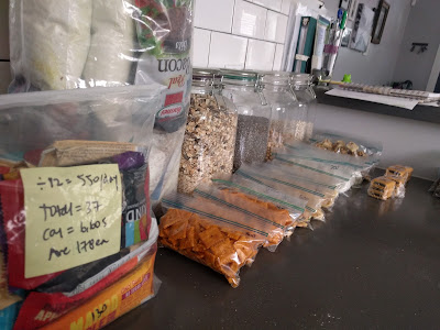
Total Distance: 225 miles
Food: Muesli, various snacks, Knorr sides, beans & rice.
Notes re food: Decided to eat hot meal in morning, cold meal in
afternoon.
Issues: Boats.
Feelings/thoughts/Misc.: Lots of light! Lots of rain and bogs.
Favorite part: Open terrain, wild blueberries, reindeer.
Base / total weight: 18 lbs. / 37 lbs.
Day 1: Monday, September 4th
2017 / 10 miles / 10/275 total / 3.5 hours / 1,635 feet gained
/ Northern Terminus: headed south from Abisko to approx. 3 km past
Abiskojuare. (Strava route)
To get to the start of the
trail, I had quite a journey. My original flight from SFO to Stockholm was
cancelled because they could not get the air conditioning working and the
temperatures in San Francisco that day were about 100 degrees. My flight was
supposed to be at around 7 pm and after sitting in the airport for hours and the
flight being delayed several times, they finally canceled it. I ran to the
check in area and rebooked my flight for the next day and got to stay in the
wonderful and beautiful Santa Clara right near the 49ers stadium. Then I took a
flight the next day, where I stayed one night in Stockholm. Since my bag had
sat on the runway for 24 hours, a lot of my snacks were basically a melted brick.
Luckily, I steer clear of chocolatey items for just that reason, but note to
self, save the yogurt covered pretzels for trips where there are no flights
involved.
On day one, I had a wonderful
European breakfast. This usually consists of different breads and then a
selection of meats and cheeses. This hotel had that plus muesli, cottage
cheese, yogurt, fresh fruit, pastries, pickles, pickled fishes, seeds, nuts,
cereals, eggs and plenty of coffee. I did a “camel up” with food and then left
a bag at the hotel, and flew to Kiruna, where I took a bus to the downtown area
where I had some time to kill so I went to the grocery store, hung out and read
and then took another bus to Abisko, where I arrived around 4 pm. I then had to
buy cooking fuel, as I could not bring it with me on the plane, and a permit to
hike the trail. I weighed my bag and it was 17 kilos (~37 lbs.) with everything
in it, including the fuel, water and 12 days of food.
I started around 4:30 pm, and I
passed a lot of people at the beginning, as the bus and train both arrived
around the same time. It's amazing how big their packs are, and how clunky
their boots! They must have way over 40 pounds in their packs. I wonder if they
plan to stay in huts, and I wonder how many days they are planning to be out
here. They seemed to be in it for the long haul. I wonder if they are planning
a resupply anywhere. So many things to ponder!
As I walked along, the trail
was very well groomed and it was mostly flat. There were some areas with trees,
which looked kind of like small birch trees or the like, and but a lot of it
was open and had scrubbier brush and bushes. Also, most of the path was hard
and packed, but there were some areas that went through wet or marshy meadows
that usually had a boardwalk built to walk on. I had read that the trail was
basically split into thirds, with the first third (where I was) being the most
poplar with well-groomed trails and nice huts, where the second third was a bit
of the wild-wild-west and you must have a tent and the trail was not as good.
The third third was the second most developed. Right now, the trail looks
pretty good! Also, today I saw plenty of water sources and even little toilets
built next to the trail! This is first class hiking!
The great part was that I got
to see the sunset and the magic hour and it's Fall here. You can feel it in the
air. Although it was warm at the start, 18° C (64° F), you could still feel
that underlying chill. Also, the Fall colors are here and they're fabulous! I
kept going and passed Abiskojuare, where there is a hut, and I am assuming many
people who I had just hiked past were likely spend the night here. I went up a
small hill for about three more miles and around 8 pm, I set up my tent on a
windy flat spot and got right in it to escape the mosquitoes. I sat in my tent
and had cold meusli for dinner. I hope the bears are scared of me because I
have my entire bag inside the tent, food and all. This would never fly in the
Sierras! As I lay in my tent and the clock struck 9 pm, it was still light out.
I was really hoping to see the Northern Lights and was thinking that hopefully
when I got up to pee in the middle of the night, as I generally do, it would be
dark enough to see them. However, I did get up to pee but did not see anything
this night.
Day 2: Tuesday, September
5th 2017 / 29 miles / 39/275 total / 11 hours / 3,052 feet gained /
From 3 km outside of Abiskojuare to Salka. (Strava route)
 |
| Lake Alesjuare |
Today was a long day and the
entire day was windy. I never took my rain jacket off! However, it was a
beautiful clear day and the views were fabulous! For a long time I had a view
in front of me of a nice snowy mountain range. The tallest mountain in Sweden
(Kebnekaise, 6,909 ft.) is not far from here, and is part of the reason that
this section of the trail is so popular. There are a couple of different routes
to the top; one is about 6 miles; the other is about 11 miles, so it is a
popular destination for Swedes and foreigners alike. I had decided that in the
interest of time and in an effort to try to complete the entire trail, I would
skip the mountain this time, as it was a bit of a side trip and I would have to
cut out something else in order to fit it in.
I passed my first lake that has
transport, although you can walk along it instead. I also saw my first Sami
village. The Samis are the native Swedish people, who hunt and fish but are
generally known for their reindeer herding. I did not see any reindeer, but
there was a cluster of Sami huts near the trail. The sign next to the lake said
that until August 31st, there were four boat transfers on the lake (Alesjuare)
per day. However, in the off season, you must call someone to come and get you and
there must be at least 6 passengers. Luckily I could walk along the side of
lake Alesjuare, but there were other lakes coming up that I would not be able
to walk along. This could be my downfall.
Just a quick explanation of the
boat system: for each lake there should be three boats. If you come to the side
and there are two boats, you can take one across and leave it on the other
side. If you arrive and there is only one boat, you have to row the one boat
across and bring another back to the first side and then row back again, so as
to not leave the person arriving next with no boat. My hope at the start of
this trip was that I would never arrive at a launch where there was only one
boat. We shall see if my dreams come true.
There were many more of the
wooden planks over the trail, as this section was a lot of chaparral type scrub
brush. However, the path underneath seemed dry enough so I wondered if this
part of the trail got moist later in the year. Whatever the reason, it
was nice, as some of the trail sections before had been rocky. Not too much so,
but enough that it was nice to have a smoother pathway. The mountains here are
not super tall and most of what I am walking on is fairly flat. It is
definitely not the Sierras, where you are always going up or down. This is a
very gradual up or down when it is either, but it is mostly flattish. The views
are great though, with wide open spaces and snowy mountains in the distance.
It’s like you never climb up and over them, just in between them.
There are these red painted
rocks along the side of the trail and sometimes I mistake them for humans, if
they are far enough away. I have seen a lot of humans too, but it is funny what
the mind does when you are staring off into the distance all day. Parts of the trail
are very rocky and they don’t have the wooden planks and they kind of hurt my
feet. It’s interesting how varied it is!
I spent a lot of time with my
head down against the wind, thinking about stuff. I'd like to think I've got it
all figured out, but I don't think that's the case. I called it a day near
Salka, where there was a hut with a few tents pitched outside. I did not want
to stay near the hut so I kept going a little longer and finally threw in the
towel just short of 30 miles because the wind was horrible and I was afraid I
wouldn't be able to find a good place to camp. In the end, I found a not so
flat spot that is a teensy bit sheltered from the wind so I decided to go for
it. It was a bit rocky, but with my pad, I figured it would not be too bad. It
was so cold and windy that I cooked inside the tent. Also, I believe the
forecast was calling for possible snow. What a change from yesterday! Just in
case, I brought all of my things up and under the vestibule or into the tent to
keep them warm and dry. Also, on a good note, my shoes are not wet yet!! 39
total miles down; 236 to go. 10 days and who knows how many boat rides to
go!!
At some point in the middle of
the night, my sleeping pad deflated. The ground under me was very cold but as
it was dark and it was the middle of the night, I figured I would deal with it
the next day.
Day 3: Wednesday, September
6th 2017 / 20 miles / 59/275 total / 8.75 hours / 1,356 feet gain
/ From Salka to Teusajaure (Strava route)
 |
| Long row ahead |
Last night was another windy
night. It seems to die down around 2 am for a little while, then it picked back
up around 4 or 5, which is when I finally got up. However, last night I popped
my air mattress and basically slept in the cold ground. Fun! I spent a long
time tossing and turning and ended up with a couple of cold hips. However, it
was okay, as the ground was peat or the like, so it was a little soft at least.
I made breakfast in the tent, as I had done with dinner the night before, and I
went to go outside and realized my shoes were frozen, as was the tent! It was
pretty chilly.
I got started right away and it
was a cold but very beautiful day. The scenery was once again fabulous and it
even changed from above the tree line with a more Alpine feel to birch forests
and beautiful fall colors. The sun was rising over the mountains as I walked
along and the sky was pink and there were little clouds in the sky; it was very
nice. The boardwalk walkways were covered in frost and it took a while for the
sun to come up over the mountains, so it was cold. I wore my waterproof/wind
pants over my shorts and my rain jacket over my long-sleeved shirt. As long as
I was moving, it was fine but the wind had a good chill to it! Once again, I
walked in a valley in between two ranges of mountains and the terrain was much
the same as before; it is kind of a peaty ground cover a lot of the time and
has very small bushes or shrubs. There is already (or still) snow on the
mountains around me.
As I walked along, at some
point I realized that some of the small shrubs I was walking next to had
berries and that they were blueberries! I spent a lot of time after that
picking and eating them. Although they are smaller than normal store-bought
blueberries, they have a lot of flavor! I probably would have walked a lot faster
had it not been for the berries. There is also a ton of water here. That is one
thing I do not have to worry about, and I am only carrying about 0.75 liters at
a time, as there is always a chance to fill up. Also, I am not filtering water
so it saves so much time and does not require as much thought or planning as it
normally would.
I am still seeing some people
on the trail, but not too many, and as we pass, we generally say hej (pronounced
“hey”), which is Swedish for “hi.” It is funny, as in the US if someone says hey
to you it seems a little bit familiar, but here it is normal; however, it seems
like everyone knows you already! Hey! I got to my first shelter today. They
have a few shelters along the Kungsleden, in case of emergency, or you can reserve
some of them. They usually have a bench or two and a stove and that is pretty
much it!
I definitely had a bonk moment
around mile 17 where I just wanted the day to be over. Well, someone must have
heard me because when I got to my first rowboat crossing, it was so windy,
there was no way I was going to try to row across. I would have to pay someone
to take a motorboat across the lake. However, even though I had arrived around
2:30, the next boat was not until 4, so I waited. But then, the driver said the
lake was too choppy and that he could not do the 4 pm run after all. I waited
with 3 German dudes from Hamburg, not associated, until a possible 7 pm boat.
This time our wait paid off and we arrived safely to the other side. I camped
right above where the boat dropped us off; the three German dudes were going to
hike a bit and then find a place to camp, but I was ready to be done. There
were a lot of bugs, and it was already pretty late, so I got right into my tent
and went to bed.
Day 4: Thursday, September
7th 2017 / 22 miles + one bus + one boat / 81/275 total miles / 9.5 hours /
3,060 feet gained / Teusajaure to just past lake Gåbddåjávrre (Strava route part 1, Strava route part 2, Strava route part 3)

I started hiking early; I have
been starting around 5 am most mornings. It was chilly, but I was hiking uphill
at first, so I did not have too much trouble with the cold. However, there was
frost all over the blueberries! After a few miles, I ran back into the German
guys, who were just breaking camp. I hiked with them for the next few miles, or
at least when I got to lake Akkajaure; it was a big one! Before that though, we
saw a bunch of reindeer which was pretty cool. We had a nice hike and chat
before getting to the lake. Everyone I talk to looks at me funny when I say I'm
trying to get to Hemavan in the next 8 days. I did the math again and I still
have to hike about 28 miles per day to stay on track, which I haven't been
doing!!! Hopefully after this lake I'll have a couple of nice long
stretches and will be able to get some real miles in. It's supposed to rain
tomorrow so that could definitely put a damper on things!
Once we got to the lake, we had
to wait for a bus, which only comes once per day (luckily, we were there before
it arrived!) and then went for about 18 miles along the side of the lake before
stopping for 40 minutes at a tourist shop. I guess the other people here are a
little more relaxed than I am, but I am ready to get going!
The bus then went to a dock
where I had to take a boat to get to the other side of the next lake
(Gåbddåjávrre; say that five times fast!). On the other side was a nice resort,
which, if I was taking my time, I would have loved to stay at and have a nice
warm room and a big breakfast the next day. Alas, I had only hiked about 9
miles that day and I was already falling behind! I did use the real toilet
before I left though; what luxury! I headed up the hill right away, saying
goodbye to my friends from the bus. I walked about 12 more miles and got to a
lake called Sitojuare, and went to the rowboat area to find that there was only
one boat. This lake was about 5 km long and with only one boat, that would mean
that I had to row it across, get another boat, row it and myself back and then
row back again, a total of 15 km of rowing! I was not really in shape for that,
plus it was getting late in the day.
Luckily but expensively a lady
was giving motorboat rides across. However, she was not leaving until she had a
full boat (this is very common; there is not a schedule; they just wait for a
full boat) and I waited on the shore in a swarm of mosquitos for other people
to show up. She finally took us across in the late evening right before it
started to get dark and I hiked for about a half a mile just to get away from
the dock before I set up camp in the shrubbery. Tomorrow there will be another
lake in the morning where I hope there are two rowboats, as the motorboat only
comes at 9 am and 5:30 pm.
Day 5: Friday, September 8th
2017 / 28(+) miles / 109/275 total miles / 13 hours / 2,400 feet gained / Just
past lake Gåbddåjávrre to Kvikkjokk. (Strava route part 1, Strava route part 2)
 |
| Wild Swedish blueberries |
I woke to cloudy skies, which
made for a nice sunrise, but was not a good indication of what was to come. I
had camped not far from the trail the night before, after having arrived late
on the boat. After having breakfast, I got up and hiked the 5 or 6 miles to the
next lake. This one was about 2.5 km across. I started early because I knew
that there was a 9:00 or 5:30 motorboat so if there was only one rowboat, I
wanted to have options. It turned out there was only one rowboat. I arrived
there around 7:45 so I decided it would probably take me about 1/2 hour each
way, which would be about 1.5 hours, so I may well wait for the motorboat that
left at 9:00 am. Luckily, I was one of the first people at the boat launch, so
I sat and read my book while waiting for the motorboat to arrive to take us
across.
I got to the other side around
9:15 and started hiking. The plan was to get to Kvikkjokk, which was about 40
km / 24 miles away. It was still very cold and I hiked with both my puffy
jacket and rain jacket on, in addition to my buff and rain pants. Things went
well until about mile 9 or 10 when I hit a wall hard. The trail was very rocky
in this section and my feet hurt. There were tons of rocks which each were
poking into my feet and making it worse. I was falling asleep while walking and
I kept thinking that maybe I would just hike less miles per day and stop at
Ammanaise (79 km before the end). I also arrived into the Sarek region, which
would be a lot less inhabited or traveled than the last section. As I
mentioned, the first third was the most popular third and had huts and things
like that. I was entering the second third, which was known for being remote
and for not having a lot of people and definitely no huts etc. One warning
said, “there are no marked trails or huts to spend the night in.” No marked
trails!? Ha. I was also going to not be close to any roads for the next
while.
I crossed the 100-mile mark and
although I was eating regularly, I was a tired and I eventually decided that I
was maybe not getting enough calories. So I sat down and had a muesli out of
the bag with no spoon (not a pretty sight). This is about 700 calories worth of
food versus the normal 100-200 I would eat per hour in snacks. It helped a lot.
That was probably around 4 pm and I finally arrived at Kvikjokk around 7:30 pm.
I arranged my boat ride for the next day with Bjorn the boat man, who asked me
how far was I going, what was I wearing, did I know it was going to rain the
next two days, did I have waterproof gear...etc. and then he showed me the map
to Jokvik and where the shelters are. He also said 8:30 is the earliest he
would be willing to ferry me across unless I wanted to pay extra! I said 8:30
is fine.
I left there and went to pitch
my tent under the trees, where it rained on me all night.
Day 6: Saturday, September
9th 2017 / 27.25 miles + 3 mile boat ride / 136/275 miles total / 11.5 hours /
3,903 feet gained / Kvikkjokk to a teepee in the middle of nowhere. (Strava route part 1, Strava route part 2)
The first thing I did
was...sleep in! I didn't have to meet Bjorn until 8:30 so I reorganized my
stuff, counted my calories, charged my items, repacked my bag etc. Besides the
tent was wet from the rain so I was in no hurry to pack up. I even had
breakfast in bed, which is something that I would never do in California, due
to issues with bears and critters. Although I do believe there are bears and
critters in Sweden, I could not be bothered to get out of the tent in the rain
to make breakfast. Also, before I knew it, it was time to go! There was one
lodge in Kvikjokk, and it had a real bathroom, which I took advantage of before
meeting Bjorn to go to the boat.
Bjorn was a wealth of
knowledge. He is 10th generation from Kvikjokk. The area has been a mining area
since the 1600s, I think he said. He took me across the Delta and gave me the
lowdown on everything from the area, such as the fact that under the Delta
there is methane gas, which Putin would like to have control over. He also said
that there were two Slovenians ahead of me that he had taken across yesterday.
He said he doesn't have kids and that the closest school is 120 km away and
only 10 people live in Kvikjokk. Its industry used to be silver mining, then
ore, but now was mostly tourism. There actually is a road that leads to the
town but when I looked at the map, it was pretty darn remote! The boat ride was
about five kilometers long and took about an hour.
On the other side of the lake,
there was an emergency shelter and a bathroom. This is pretty common, as I've
seen this on each lake. In this one though, Bjorn had a two-way phone which you
could use to call him with once you arrived. He gave me his website address and
email and showed me a photo of his potato plants and we parted ways. He once
again reminded me that it was going to rain for two days. He told me about a
Sami teepee which could be used for an emergency shelter if needed.
As I waved goodbye to Bjorn and
set off up the hill from the delta, it started raining. The first few miles
were through the forest and were really beautiful. However, it was quite rainy
and foggy so the views weren't great. Next, there were big marshes with
striking yellow grasses and little ponds. Next was what I think may be called
the skierf, but is essentially exposed tundra with rocks and small scrubby
bushes, usually blueberries and a type of small juniper looking plant. It's a
bit dangerous as the juniper plant also has blue colored berries. However, that
does not stop me from picking the blueberries; just don’t eat the juniper
berries! When I got to this section, the rain had become hail/rain and the wind
was strong at my back. It was cold, and walking through the scrubby bushes got
my pants wet to the knees, while the wind blew the rain hard against my back.
Basically there was no way to stay dry, no matter which way you were
facing.
I was in a great mood though.
Funny, some days I really think about a lot of things, I write letters in my
head to people, I think about what I should do when I get home, etc., but today
I just walked, and thought about the Slovenians. I kept wondering how far they
would get. I ran into an English girl who was headed north and she said she had
met them in an emergency shelter that was 12 miles from the lake. I kept
wondering if they would make it to the teepee which was 42 km from the lake
because I was thinking that if was really wet and stormy, I may try to stay in
the teepee. I kept doing math in my head and would guess where our paths would
cross and what I would say to them when/if they did.
Other than that, I don't think I
did my normal letter writing thinking process. I just walked with my head down
against the wind and rain and watched where I stepped. The terrain was much
more forgiving, with dirt paths and not as many rocks. However, it was very
boggy and wet and my feet were soaked within minutes of starting out. Then once
the rain started beating my back a lot, probably a few hours in, I could feel
my capris and underwear start to get wet. I was trying to figure out the
logistics of setting up the tent in the rain without everything getting wet and
it was feeling a bit grim. I kept thinking that this teepee was going to be my
salvation.
I did pass the shelter that the
English girl had told me about and I stopped there for a minute to get out of
the wet, but I knew that I could not stay and that it would do no good anyway,
as I would get wet again as soon as I went back outside. I wanted to press on
to get as far as I could tonight and hopefully to the teepee!
I passed the Slovenians around
km 40. They were already in their tent. I wanted to try to get to the teepee
before dark, but since I started late, around 9:30 maybe, getting to 42 km
would take me at least 10 hours (@ 2.5 mi/hour). After I passed them with a
quick wave, I kept walking and then it started to get dark and for a while I
was not even sure I would be able to find the teepee in the dark. I had to stop
to get out my headlamp and when I opened my bag, it was hard not to get the
contents wet. I was in a bit of a funk at that point, as I was soaked and now
my stuff was going to be soaked.
After hiking for what seemed
like forever, I finally found the teepee. I'm pretty sure it was a little
farther than the 42 km stated, as I didn't arrive until maybe 8:45 or 9 and it
was fully dark already. It was not what I was expecting at all. I guess after
seeing some of the emergency shelters, I thought that the teepee would be made
of wood and would be dry and clean inside. Instead, it was a mound of dirt and
twigs with a dirt floor and a fire in the middle of it, kind of like what I
imagine the Native Americans used. Also, when I opened the door, the fire was
slightly burning (and smoking) and there was a person inside sleeping! At
first that made me wonder if I should go back out in the rain and set up my
tent, but then I decided just to try to make friends.
The person turned out to be a
Dutch man (Hank) who was doing a NOBO trip from Hemevan; he happily shared the
space and was quite nice. However, the roof make of twigs was not waterproof
and it was a bit leaky and I slept right on the ground but at least I could
hang up my clothes. I took off most of my clothes and huddled in my sleeping bag
on top of my tarp, but I could hear a dripping (and feel it) near me and I knew
that my sleeping bag was going to be wet the next day. I took off my pants and
underwear in a hope to dry them, but I think the hanging clothes may have
gotten caught in the dripping cross fire too. Due to listening to the dripping
and worrying about being wet, I got the worst night’s sleep! I probably should
have just set up my tent and then I could have properly undressed and prepped
everything, but instead I went to bed half wet and freezing cold.
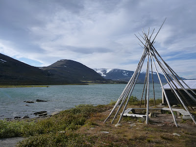
Day 7: Sunday, September
10th 2017 / 13 miles / 149/275 miles total / 6 hours / 900 feet gained / A
teepee in the middle of nowhere to Vuonatjviken. (Strava route)
 |
| The teepee |
I got up, talked to Hank while
having breakfast, and sent him on his way. After that I lit a fire in the teepee
to try to dry my clothes, which helped a little but mostly made them stink like
wood smoke. I got back on the road and within minutes, I was completely soaked
again. I started off on the tundra again with high winds and rain/hail and was
immediately cold and wet. I knew it was going to be a long day. My gloves (and
therefore hands) were already wet and cold and I walked downhill and sometimes
even ran to try to keep warm. I arrived at Vuonatjviken, where I would have to
take a boat across, around noon. The lady said the next boat would maybe be at
3 pm, but to check at 2:30. I asked if there was a dry place to wait and she
said no, but they have cabins for rent. I said no thanks, so she said I could
wait on one of the porches. It was wet and cold and I was soaked through and
after sitting on the porch for a few mins, finally I decided to just get a
cabin and take the next morning’s boat. This would make for a few long days of
hiking, or maybe an early exit, but I figured it was worth drying out and
getting warm and waiting out the storm a little.
I got a cabin and spread all my
stuff out to dry and ate a nice warm meal and had an extra coffee, even though
it would mean I would have to go without later. Then I went for a shower, which
was not in my cabin but in a separate room. This room also had a boot drying
station which was like a big inverse vacuum that blows hot air inside your
boots. I put my sneakers on it but they were not dry by the time my shower was
done. However, they were not as wet as before! As I was leaving the shower room
to go back to the cabin, I encountered a girl who asked if I would be willing
to share my cabin with her and I said sure. She turned out to be a German girl
named Pauline, and we had a nice time chatting about gear and hiking and this
and that. Before we knew it our clothes were dry. Also, the Slovenians caught
up to us! They came and knocked on our door and asked if they could hang some
of their wet things in our cabin, as they were going to camp outside on the
grounds of the property. We said yes of course. So I guess the 2:30 pm boat
ride never happened! I am glad I got a place to stay after all.
I talked to the landlord and
they said the first boat the next day would be at 10:30 am, so once again, I
had to recalculate my mileage, as these boat rides were causing delays that I
had not been aware of. My calculations were as follows: With the next day's
late boat ride, I would likely only be able to get in 20-25 miles and would
then probably have three very long (34 mile) days to Hemavan. There is one
rowboat crossing left and then it's smooth sailing. Barring a big storm or
something bad happening, I was still hoping that I could make it all the way.
Day 8: Monday, September
11th 2017 / 21 miles + 0.80 mile row / 171 / 275 miles
/ 8.75 hours + 40 min row / 2,700 feet gained / Vuonatjviken to just
past Luvtavrre. (Strava route part 1, Strava route part 2)
Unfortunately, this was a short
day due to the 10:00 am boat ride. The cabin owners brought me, Pauline, the
Slovakians and one other girl with a huge pack (everyone has such a huge pack!)
to the other side and at about 10:30 am I set off ahead of the others pretty
quickly. About 7 miles later, I got to a lake where there was a rowboat
crossing.
At this crossing, not
only was there only one boat on my side but only one on the other side too, so
that everyone would have to row! It took me about an hour to untie the boat,
empty the water, push it down the ramp and then row across, do the same to the
other boat, and then row back across again. Just as I was leaving the first
side again, Pauline came along, so I rowed back and she did the final row of
the day. First of all, she is a way better rower than I am. In fact, I am so
dumb that I rowed backwards at first, but luckily nobody was there to see me!
After I realized that it seemed way more difficult than in should be, I
remembered that I should be facing backwards instead of forwards like I was
sitting and then it was much easier. However, I am still a T-Rex with tiny arms
and it was still hard! Pauline just breezed right across the maybe 500 or 600
meter stretch.
After that, I went about 14
more miles before it started to get dark so I had to find a place to rest.
Luckily today there were only in and off showers so I did have time to dry
before getting into my tent. However, by the time I decided to stop, it was
dark and there were no flat spots so I camped on a mossy knoll and got the tent
up just before the heavy rain began again. Did I also mention that the trail
has been very boggy lately? Also due to the rain, all the bushes are wet and
when you walk through them you get soaked! I am basically wet from the ground
up even when it is not raining.
This was my best night's sleep
on the trail. It was not very cold and I could keep my head out the whole time,
plus the mossy knoll was cushioned. However, I did not realize that the wet
moss would eventually soak through! Before going to sleep, I had a hot dinner
as a nice treat and was planning to have a hot breakfast the next day as well
(I had been doing only one hot meal per day) as my plan for day 9 was to go
from 6 am - 8 pm so that I could try to still make it to the end.
Day 9: Tuesday, September
12th 2017 / 28 miles / 199 / 275 miles / 11 hours / 2,300 feet gained
/ Just past Luvtavrre to a wet bog near Lisvuojavrrie. (Strava route)
When I got up it was raining
and the inside of my tent was wet. Apparently although the moss is soft, when
it rains, water pools under the lowest spot, aka under me. When I got up there
was a puddle underneath me. Luckily my sleeping bag was only a little wet, but
my pad was wet as was the inside of the tent. I packed up the wet tent
and tried to keep my sleeping bag dry. I started off at 6 am and it poured down
rain all day. And was windy and cold the entire time. Most of this day's
stretch was above the tree line so was totally exposed. In addition, it was
boggy as hell and there was pooled and running water everywhere. In addition,
the rain was being blown into my face, so basically I marched, head down, as I
got more and more wet.
There is something very
disheartening about tromping along in a pouring rain. Firstly, I did not take
any/many photos, as getting the camera out goes a little something like this:
let’s pretend that your lower layer, your fleece for example, is currently dry.
Over that is your rain jacket, which is wet on the outside. You are wearing wet
gloves, so your hands are freezing. Now, you need to get your camera out from
an inside pocket. You lift up your rain jacket, take off your glove and reach
into the pocket to get your camera. In the meantime, your fleece is getting
rained on. You get the camera out, take a photo as the camera gets wet, put it
back, also getting your fleece a little bit wetter in the process and keep
walking. Each time you do this, your fleece and other dry layers get just a
little bit wetter. Secondly, the same story is true for food. You have to take
off your glove(s), get the food out from wherever it is hiding, eat it, put it
back. Sometimes it is just easier to tromp along without eating or drinking or
taking photos or doing anything fun! Then you start to be colder and hungrier
and you are thinking that you came here for the scenery but you are not even
looking at it or taking photos of it so what is the point! Of course, being all
alone means that there is nobody or nothing to distract you from these thoughts,
so they go over and over in your head as you walk along in the cold rain.
Finally, around hour 9, I
started thinking that I had not seen a sufficient spot to put my tent in hours.
The land was sloped and boggy with lots of standing water. By now even my pants
and underwear were soaked and I started to get worried as I knew the inside of
my tent was wet as well. Around the 11-hour mark, I decided to throw in the
towel. As soon as I decided that and found a slightly not as wet spot and
decided to pitch my tent, the rain and wind picked up in full force. I was a
pathetic sight, trying to pitch my tent in the wind and freezing rain with
frozen stiff fingers. Once pitched, the inside was even wetter, so I took off
all of my clothes except my t-shirt and bra which were not as wet as everything
else, wiped down the inside of the tent with my long-sleeved shirt, put a piece
of plastic on the tent floor, blew up my not too wet thank goodness air
mattress, put on my (only dry item) puffy jacket and climbed nakedish and quite
freezing into my sleeping bag. I probably lay there shivering for at least an
hour before my feet even started to thaw, and the wind and rain threatened to
beat down my tent (luckily, I have learned the hard way the benefits of
staking). At that point I grabbed a snack which I ate while lying sideways with
the covers over my head and praying that I would not have to go outside to pee.
Have I mentioned that my air mattress doesn't stay inflated? This was not the
best night's sleep I have ever had.
Day 10: Wednesday, September
13th 2017 / 11 miles / 210/275 miles / 4 hours / 260 feet gained
/ A wet bog near Lisvuojavrrie to Ammarnäs. (Strava route)
**Side note --> my Garmin
is shortchanging me. I got to Ammarnäs, which means I should have 79 km or
~ 50 miles left, therefore completing 225 / 275 miles, not the 210 that I have
added up so far.
I woke up on day 10, if you can
call it waking up, since I felt like I never slept, to the sound of... you
guessed it, wind and rain!! Woohoo. I made a hot breakfast while sitting in my dryish
sleeping bag with my puffy on and dawdled a bit, hoping that it would abate a
little and that my wet clothes from yesterday would magically dry before I got
started. No such luck. Finally, I just ripped off the band-aid, got out of the
warm sleeping bag and put back on my wet (very, very wet) clothes and took down
the tent, again in the blustering rain and wind. I swear it picked up just in
time for me! Now the inside of my tent was hopelessly wet. I started walking,
as that's really all I could do. However, the rain and wind came down in
torrents. I was getting sick of it and really was not looking forward to
another night in a wet tent or another day with all wet clothes. It took me a
while, but after a lot of pondering I decided to do a weather forecast check
in Ammarnäs, and then possibly quit there if it was forecasted to rain for
the next two days. It wasn't an easy decision though, as I was currently on
track to finish, and with no really long day even!
I got into town and the weather
forecast was rain for the next two days. So I got the bus schedule and decided
to call it. I changed into dry clothes for the first time in a while, my only
outfit being leggings and flip flops, had a coffee at the market and waited for
the 12:30 bus. The guys at the market were very helpful with looking up times
for trains etc. for me and even let me have the coffee for free! Before I knew
it I was in Umeå waiting for the overnight bus to Stockholm. I went to the
grocery store there and got lots of lunch meats and cheeses (oh fresh food!
Yay) and then went to the bus station and went for a beer at the bar. Then I
got an overnight bus to Stockholm, luckily snagged the last seat even without a
reservation and sat next to a really nice, clean-smelling lady (I cannot say
the same for myself; she must have been gagging at my smell). I arrived in
Stockholm around 7 am and went back to the hotel that I had stayed at and they
would not let me check in early. I walked around town and went and got a coffee
and a couple of pastries and read my book before I could finally check in and
shower! Side note: my feet were so swollen. When I got on the bus to Stockholm,
they were fine, but when I tried to get off, it was hard to walk down the
stairs. That day, they looked like two large sausages, but they did start to
get better after 24 hours off of my feet.
For the next two days, it rained
most of the time. I washed all of my stuff in the shower, went for exploratory
runs, ate the rest of my food and read my book in my room. I went downstairs
each day for breakfast and ate one of everything! Otherwise, I had a great time
relaxing and wrapping up my trip in a different way than I had anticipated!
Fun fact: Did you know that Sweden has over
97,500 lakes larger than 2 acres!? In
the US, although Minnesota is dubbed the land of 10,000 lakes, it is
actually Alaska that has the most, with about 3,197 officially named natural
lakes and 3 million unnamed natural lakes. BUT, Minnesota has the most named
lakes with about 15,291 natural lakes, 11,824 of which are greater than 10
acres.
Have you ever camped in the
rain? What tips do you have to keeping the inside of your tent etcetera dry?
Have you ever rowed a rowboat?
You can find a links to some of my favorite hiking items here.