Planning a week long hiking trip is fun, if you are an excel nerd, or
maybe a chemist, or an outdoor enthusiast. Okay, never mind, it is
actually fun no matter what! For me, planning is part of the package
that makes up the perfect gift, a trip of a lifetime. I am not going to
go into that here; you will be able to read more about that in part
three, the trip report. For now, I will just say that the work that goes
into something, be it the planning or the hiking or the sweat and the
tears, or the cold nights and long days, makes the reward all that much
more sweet.
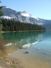
The Plan: So the first thing I had to do was figure out where I wanted to go. I had been wanting to hike the Sierra High Route (SHR), which is an off trail route in the Sierras, for some time. However, it is about 200 miles long and at my estimate, I could hike about 20 miles per day, which would put me at 10 days, or too many days to do the trip on a one week vacation. So I looked for other options and found the Wind River High Route (WRHR), which is in the Wind River Range of Wyoming, very close to Jackson, Yellowstone and the Tetons. However, I will admit, I had never heard of this section of the Rockies before. However, this route, which was also off trail, was closer to 100 miles, which I figured I could do in one week. So, I invited my ultrarunning friend Dr. G and the planning began.
The Route: We used the Andrew Skurka guide, along with CalTopo maps and the app "Offline Maps" which has USGS topo maps that you can download to use offline. Skurka gives you a few GPS way points but the route is not mapped out for you. Dr. G loaded the waypoints into the Offline Maps as well. We also had a compass and paper topographical maps.
The Big Three: Next, it was time to get my gear list together. Luckily, I have a skeleton list already made out for other trips, so that part was not too much reinventing the wheel. However, this time, I wanted to finally buy some of those elusive lightweight items that had been on my wish list for so long. The main one was a sleeping bag. They say that there is a "big three" of hiking: the sleeping bag, the sleeping pad and the tent. These items, aside from food, are generally the heaviest in your pack. I had been shopping around for a lightweight but not super expensive sleeping bag for years and had even bought one once which turned out to not be warm enough. This time I bit the bullet and spent a little more in the hopes that this time I would have the sleeping bag of my dreams (see how I did that?)
I bought the following and will likely review them at some point: Western Mountaineering Ultralite 20 degree sleeping bag (29 oz), Hyperlite 2400 Southwest Backpack (28.6 oz), and the Therm-a-Rest NeoAir Xlite Small size (8 oz). Dr. G carried a two man tent, which weighed about 2 lbs (32 oz). Therefore, my big three + my backpack only weighed about 4 lbs, or if you include the weight I carried to compensate for not carrying the tent, it was about 5 lbs. To put it in perspective, my old backpack, which I love and have used a lot, weighs about 5.5 lbs empty. Yes, I said empty!
The Clothing: For clothing, my plan was to wear the following: running shorts, short sleeved running shirt, underwear, bra, socks and Saucony trail running shoes (Nomad). I would carry the following: Mountain Hardware windbreaker, long sleeved running shirt, Montbell rain jacket, rain pants, beanie, buff, gloves, MH down jacket, sleeping shirt (long sleeved), NorthFace tights, extra underwear, socks & bra. All of the clothing I carried (not counting clothing worn) weighed about 39 oz or 2.5 lbs.
The Other Stuff: I also had to bring toiletries, kitchen items (pot, pan, spoon, bowl, fuel, matches etc.), first aid, dry bags, water purifier, electronics (phone, charger, headlamp, camera etc.) and other utility items (knife, rope, compass, trash bag, whistle etc.). All together these weighed about 4 lbs.
Base Pack Weight: This is all things, excluding consumables, which include food, water and fuel. My goal was to keep this weight under 20 lbs, as I estimated food would be about 1.7 lbs per day x 6 days, which would be about 10 lbs, and I wanted to keep my pack under 30 total lbs. My total base weight ended up being about 11.5 lbs!! I was very excited about this.
The Food: This was the most fun but definitely the most time consuming portion of the planning. Oh my, I just said "portion." Ha. Seriously though, the goal is to carry the most amount of calories in the least amount of weight. We planned to try to have approximately 3,000 calories per day worth of food, which would hopefully be no more than 1.7 lbs per day. This sounds easy, right? You just load up your pack with Top Ramen and PowerBars, right? Nah. My goal was to have food that: (1) is nutritious, (2) tastes good, (3) is inexpensive (no $8 Mountain House meals), (4) can just have hot water added to it to cook and that (5) has some variety.
So I did a lot of weighing and calorie counting and math and came up with this food plan: Breakfast consisted of either muesli or oatmeal with milk, nuts and freeze dried fruit. Both were about 700 calories. There would also be coffee, with powdered milk and sugar, which would be about 80 - 100 calories. Lunch and snacks would consist of various nuts, bars, jerky, and dried fruit and would consist of about 1,200 - 1,600 calories per day. Dinner would consist of a curried top ramen dish, a mashed potato with bacon dish or a rice and beans dish, each clocking in at a little over 700 calories. I also brought olive oil to supplement, which is about 100 calories per serving. All in all, the goal was about 2,600 - 3,000 calories per day.
The H2O: I brought a 1.5L bladder and a 0.5L soft flask for water. Each liter of water weighs about 2 lbs, but my plan was to try to carry the least amount possible and fill up frequently, so as to keep the pack weight down.
Total Pack Weight: My food ended up being about 1.4 lbs per day. This, plus an estimated liter of water, would bring my total starting pack weight to about 23 total lbs. HOWEVER...Dr. G carried the tent and I carried some of his food, which brought my total up by about 4.5 lbs bringing my actual starting pack weight to 27.5 lbs.
The Verdict: This is the lightest I have ever been when doing a multi day backpacking trip. I lugged over 40 lbs up Mt. Whitney for a one night trip. I will (hopefully) never have to do that again. The pack felt comfortable and even when climbing up a steep rock or going through a tight squeeze, it was not too cumbersome.
A couple of things I would probably leave behind: the olive oil (it leaked plus we never used it), the all purpose soap (I did not shower, bathe, or use soap to do dishes or clean clothes like I thought I might), my sleeping shirt (I slept in my hiking clothes, although it is nice to have a possible dry shirt if needed), sports bra (I wore one and brought a spare and ended up wearing neither in the end) and my just-in-case tank top (it was never warm enough).
A couple of things I might bring some of / more of: gauze (I had tape but no gauze and I got a pretty big scrape which could have used a bit bigger of a cover), socks (I brought one spare but having wet feet is a pain), a different water carrying system (more on that in the trip report) and a different/newer charger (my solar charger is old and ran out of juice fast, plus it was not sunny so I could not recharge it).
A couple of things I could not have lived without: this Picaridin bug lotion (NO bug bites when applied, even with mosquitoes SWARMING), Advil, Neosporin / Bandaids / Leukotape (as mentioned above, I got a scrape and it was nice to have something to clean it), earplugs (my tentmate was a snorer, plus the sleeping pads are loud) my new sleeping bag (fabulous! We spent one night in a snowstorm and I was not cold at all), maps/compass/GPS (after all, this was an off trail trek), Garmin 910ST, camera (I took about 800 photos), Yaktrax (I almost left them behind), and nuts (fat, protein and carbs all rolled into one, which keeps you feeling more full throughout the day).
In the end, I ate every speck of my food, except for the olive oil and one packet of Justin's Peanut Butter. I also used everything in my bag, except for the few things mentioned above and any emergency items (rope, knife, first aid). There was nothing that I really missed or really felt was dead weight. I felt that the packing ended up being pretty much perfect. I may try to compress a few things down a bit more with a compression sack so I can fit a little more if I am hiking for more days. I also need to figure out my water system and probably configure one extra pocket on the front of my pack (my pack has two hip pockets but no chest pocket). Otherwise, things are looking pretty good!
Have you ever planned for a long hiking or backpacking trip? Or maybe a long vacation? What is your logistical planning strategy?