
My family likes to scale tall things. I have mentioned before how my Dad and his friends like to climb to the highest points in each state, but we also like to climb anything tall. Or taller than something else. Or not tall at all. So...pretty much anything.
For instance, we have climbed to the top of Mt Shasta before. The last time we did it was June of 2009. So we figured we were about due for another trip. (However, I just read the recap from last time and I realize it's funny how easily we forget how difficult things are!)
Base camp is at approximately 7,000 ft. The top is at 14,179 ft. It really is pretty much straight up on the way up and if you are lucky, it is snowy, and you can glissade (slide on your butt) half of the way down. That's an approximate elevation gain of 7,000 feet. After races like this, it would seem easy, right? It's not. The high elevation really takes every bit of energy you've got out of you.
So Broski and I are "training" a bit. We never intended to train, but I had a free day a few weeks ago, and he and I decided to hike what we thought** was the tallest mountain in his county, Sonoma County. This is called Hood Mountain (#1), and is about 2,733 feet.
It was approximately 3 miles each way and the day we did it, it was about 100 degrees. We did not bring enough water and there was no water along the way. To top that off, I ran into a poison oak bush with my face near the top and so we ran down to try to get to a stream to rinse it before the oils set in. However, it was a pretty cool hike. From the top you can see Napa Valley, Sonoma Valley and the Pacific Ocean. (**note: the tallest one is actually Mt. Saint Helena at 4,342 ft. Boy were we off by a few feet!)
Next up was Marin County, where the tallest is Mt. Tam (#2), at 2,574 ft. As a sidenote, there is a really famous trail race called the Dipsea, which I will actually probably tell you more about tomorrow because otherwise this post is going to be way too long... Let's just say that we took the long way to the top of Mt. Tam (via the Dipsea trail), so our hike lasted all day. It was a great hike though, taking us past the ocean, through the redwoods, and to the top of many a grassy knoll. If we would have went straight up, it would have been about a 2,500 ft elevation gain, but we took a detour, which caused our climb to be about 5,000 ft instead. This hike took us about 9 hours, since we did the detour, which caused our total mileage to be about 22 miles.
This time we brought enough water. In fact, Broski carried about 8 liters (and two beers!) and I carried 2.5 liters. We were so paranoid after the dehydration from Hood Mountain! However, there were places to fill up your water this time. But we were really glad we brought our own because we froze all the bottles so we would have cold water and it was so nice, since it was about 90 degrees that day and was really dusty to boot!
Up next is Mt. Diablo (#3), the tallest in Contra Costa county, at 3,849 ft (source). We are ready!
I am not sure this will truly ready us for the thin air of Mt. Shasta, but it's worth a shot and it's fun to do regardless of whether or not it's helping! Of course it's much easier to hike with a tiny Nathan hydration vest rather than a 40 lb pack!
Do you like hiking? Do you have a favorite type of hike? What is your weekend hobby?
For instance, we have climbed to the top of Mt Shasta before. The last time we did it was June of 2009. So we figured we were about due for another trip. (However, I just read the recap from last time and I realize it's funny how easily we forget how difficult things are!)
Base camp is at approximately 7,000 ft. The top is at 14,179 ft. It really is pretty much straight up on the way up and if you are lucky, it is snowy, and you can glissade (slide on your butt) half of the way down. That's an approximate elevation gain of 7,000 feet. After races like this, it would seem easy, right? It's not. The high elevation really takes every bit of energy you've got out of you.
So Broski and I are "training" a bit. We never intended to train, but I had a free day a few weeks ago, and he and I decided to hike what we thought** was the tallest mountain in his county, Sonoma County. This is called Hood Mountain (#1), and is about 2,733 feet.
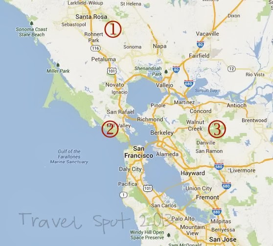 |
| 1: Hood, 2: Tam, 3: Diablo |
It was approximately 3 miles each way and the day we did it, it was about 100 degrees. We did not bring enough water and there was no water along the way. To top that off, I ran into a poison oak bush with my face near the top and so we ran down to try to get to a stream to rinse it before the oils set in. However, it was a pretty cool hike. From the top you can see Napa Valley, Sonoma Valley and the Pacific Ocean. (**note: the tallest one is actually Mt. Saint Helena at 4,342 ft. Boy were we off by a few feet!)
 |
| View from the top of Hood Mountain |
Next up was Marin County, where the tallest is Mt. Tam (#2), at 2,574 ft. As a sidenote, there is a really famous trail race called the Dipsea, which I will actually probably tell you more about tomorrow because otherwise this post is going to be way too long... Let's just say that we took the long way to the top of Mt. Tam (via the Dipsea trail), so our hike lasted all day. It was a great hike though, taking us past the ocean, through the redwoods, and to the top of many a grassy knoll. If we would have went straight up, it would have been about a 2,500 ft elevation gain, but we took a detour, which caused our climb to be about 5,000 ft instead. This hike took us about 9 hours, since we did the detour, which caused our total mileage to be about 22 miles.
This time we brought enough water. In fact, Broski carried about 8 liters (and two beers!) and I carried 2.5 liters. We were so paranoid after the dehydration from Hood Mountain! However, there were places to fill up your water this time. But we were really glad we brought our own because we froze all the bottles so we would have cold water and it was so nice, since it was about 90 degrees that day and was really dusty to boot!
 |
| From the top -- with view of the TINY city in the background |
Up next is Mt. Diablo (#3), the tallest in Contra Costa county, at 3,849 ft (source). We are ready!
I am not sure this will truly ready us for the thin air of Mt. Shasta, but it's worth a shot and it's fun to do regardless of whether or not it's helping! Of course it's much easier to hike with a tiny Nathan hydration vest rather than a 40 lb pack!
Do you like hiking? Do you have a favorite type of hike? What is your weekend hobby?