Showing posts with label biking. Show all posts

11.14.2024

Bikepacking Route Planning

NGS asked me to really break down (into the nitty gritty, I think she said) the logistics for my trip. Since route planning is one of the things that takes the most time, I will start with that. Route planning is kind of a three step process: (1) prior to leaving, (2) weekly check ins/general routes (3) daily/last minute updates. 

(1) Prior to leaving. Before I left on my trip, I started by figuring out a general idea of how I wanted to do this. You would think it would be very calculated, but really for me, it went something like this. First, I knew that I wanted to do the Great Divide Mountain Bike Route, which goes from Banff, Canada to Antelope Wells, NM (the Mexico border). However, instead of going "straight" there, which may have taken me through Nevada and Idaho before getting to Canada, I decided to visit some friends along the way. I also had winter to contend with so knew that I could not really go anywhere where it was still quite high in elevation or high in latitude. For this reason, I decided to stay near the west coast for a while, where it would hopefully be warmer. I also knew that when possible, I wanted to go on dirt instead of highways. 

To find routes, I used a combination of Bikepacking.com, other bikepacking websites and blogs, Komoot and Google Maps. Bikepacking.com has prearranged routes, with descriptions and maps that you can download. I chose to do the Oregon Outback through Oregon and the BC Epic 1000 from Hope, BC to Fernie, BC. To connect the two, I chose to use some of the BC portion of the Great Northern Bikepacking Route and then the Great Divide Mountain Bike Route from there. Then I used Komoot and Google Maps to fill in the gaps. 

For both of the above, they have maps that are usually made with the Ride With GPS site, and can be downloaded and/or exported to your navigation device. I have a Garmin Edge and so I then export the route to the Garmin for use on the road. You can also edit the routes on Ride With GPS, but I normally do my editing in Komoot. 

The Garmin Edge is like any other GPS navigation tool; it will tell you when to turn, how far you have gone, how fast you are going and what your elevation is etc. It also has a hill feature, where it will tell you data on each hill: how far it is from you, how long it is, and when you are on the actual hill, it will show an elevation profile. This is probably my least favorite aspect as it generally means I am struggling, but it is handy. 

Regular mileage/data screen


Turn by turn

Hills! Dark red is my enemy!

Komoot is like Google Maps, but it has options for dirt, gravel or road, and can also be used for hiking for the same reason. With this, you put in your start and end and then choose your method (road biking, mountain biking, gravel, touring) and it will figure out the best route for you. This needs to be taken with a grain of salt, as it often will take you on private or closed roads, or will go off the main route to get a more scenic route, which often results in more hills or more turns. However, it is a good start. Once the route is complete, you can save it offline into your phone, and/or you can export it to a navigation device. Note, this will also tell you your elevation gain and loss, total miles, time it will take, surfaces and way types along with an elevation profile. 


Google Maps was mostly used to look at city routes and to compare with the route that Komoot came up with to see if they or where they differ. However, I cannot export the Google Map to my Garmin, so before leaving, it was used more as a fact checker than anything else. So basically, before I left, I had the maps for my trip all the way to Antelope Wells, NM and I figured I would sort the rest out later. 

(2) Weekly check ins. As you already know, right from the get go, the snow caused me to have to change my route from California, as I had planned on going up and over some 6,500 foot mountains, but ended up having to take the lower, more flat, more road heavy route. This happened later a few times as well. What do I do in this case? I edit my existing Komoot maps, by doing a "save as" and I resave the existing route with a different name and then edit that accordingly. For example, my first iteration was Grass Valley to Klamath Falls via mountain, then the next was GV to KF via road, then the next one was GV to Redding via road! Every time I get into service and have a room, I double check the routes and the weather and update the route accordingly and re-export it to my Garmin.

Sometimes I can find a route someone else has already made on Ride With GPS and then I just use their map. For example, in BC I was going to do the BC Epic 1000 route, which goes over Gray Creek Pass. When I was in Vancouver, I posted on the BC Epic1000 FB group to see if people thought I would be able to get through and/or to get any intel on snow conditions, and I was told that I likely would not get through, so I searched on RWGPS for Gray Creek alternate, and found a map going around on a lower route. I downloaded that, exported it to my Garmin and I was ready to go. 

(3) Daily/Last Minute Updates. This does not happen a lot, but sometimes there is construction, or snow where I did not know there would be snow, or a road is closed and/or private. In this case, if I have service, I can make a new map and it will sync with my Garmin. If I am out of service, I just have to keep looking at the map, which is saved offline on my phone, in order to figure out where I may be able to go. I also always download all of my Google Maps to be offline in case this happens and even though I cannot use the biking directions when I am offline, I can at least see which route a car would take and how many miles/km it is to my destination. 

I also have to check the route every few days depending on what the accommodation options are. If I am in a national forest, this is easy, as I can generally camp wherever I want. If I am in civilization, often my daily mileage is decided by where the next place to stay is. I try to figure this out every few days so I am not doing back to back long days with no services in between. I also like to have a room at least once per week; otherwise I get cranky and hungry and stinky, so I may prepare my route to do a long day today so that I can have a short day of riding and a long day in town tomorrow. 

I know that is a lot, so here is the TLDR (at the end!) 

Bikepacking.com: tried and true pre-made routes (usually multi-day & more off road)
Ride with GPS: GPS routes that anyone can put online (may need verification) / can make own route 
Komoot: GPS routes that anyone can put online (may need verification) / can make own route
Google Maps: best for towns/roads/use offline for general area

Alternative tried and true sites: Great Northern Bikepacking, Bikepacking Roots, Adventure Cycling Association (fee required). 
Alternative mapping tool: Gaia GPS

What route planning tools do you use for your hikes/runs/bike rides/road trips? If you are going for multiple days, do you always plan out every day beforehand or do you have some days that are ad hoc? 

If you haven't already, you can fill out this form with any questions you want answered for my upcoming ask me anything post!!

This post is part of NaBloPoMo. You can find the rest of my posts for this challenge here. You can find the list of participants and their information here. P.S. This is a draft I started in September 2024! I am clearing off the dust here! 

8.26.2024

You Can Do It!

The most common thing that people say to me, aside from where I am going or where did I come from, is that they wish they could do what I am doing. I always say to them that they can, and I do believe that is true. For those of you who don't already know, I am currently riding my bike around the US and Canada, mostly camping, and trying to stay off the paved roads. 

I wanted to break down this comment a little; do these people really mean that they wish they could do it? Or is this just a figure of speech, an automatic response, a compliment to me, or a placation? 

I would like tomatoes as plentiful and as delicious as my brother's. However, the truth is, I don't want to spend the time prepping and planting and watering and I definitely don't want to spend my summers harvesting and canning and preserving. So I leave that to him and I go off and ride my bike and when I go home, I get to go to his house and eat delicious sauces. I think most people who make this comment just want to go home and eat delicious sauces, or in the case of a bike, have it ready to go for when you want to do a few mile, preferably driving to the best spot and enjoying the best part of the ride, with good weather and views around ever corner. 

To do new things, it takes work. You have to get out of your comfort zone and cede some control to other people, the unknown and life in general. I literally do not know what's around the next corner most of the time, and this is hard. I am a type A planner, but in this case, I am often going day by day, because (a) you will just disappoint yourself if you have too high of expectations or you try to control every moment and (b) it's actually part of the fun. I sat in Tim Hortons the other day talking to an old local man, but I really really needed to charge my phone and book that night's accomodation, which is why I went in there in the first place, and afterwards I needed to go grocery shopping, and it was supposed to start raining soon. However, we had a great chat and this will be a story that I tell later, and it did not really take away from my day, except that I got rained on a little and arrived at my accommodation later than I wanted to. But! It was still light and I had plenty of time to set up and eat and enjoy the sunset, so really it did not change my day for the worse at all. 

However, people, including me, have a hard time doing new things because we do lack that sense of control and we do have unknowns lurking, just waiting to hit us when we are down. However, I think the positive unknowns outweigh the negative ones by a long shot. 

So, people, I am here to say that you CAN do it! Two years ago, I had only mountain biked once in Bolivia, and they did not provide me with any instructions, so basically you could call that a non-event. I had never owned a mountain bike. I had never ridden any bike, mountain or non, more than 40 miles. I had never done any bike maintenance but change a tube. 

I get embarrassed easily; I am afraid of looking or feeling stupid. I know this has kept me from trying some new things. Puedo hablar español pero tengo vergüenza cuando hay la gente circa me! I listened to a podcast with a writer from Outside magazine, who is in his 50s, and he said he is going to try all kinds of new things, and be that 50 year old looking stupid, and also help those 50 year olds who want to try new things but have fears that it is too late or that they will look dumb or embarrass themselves. It is not too late, but it is not as easy now as it was when we were 20 and fearless. 

For this trip, I had to learn a lot of things, and I had to have some bad days, and I had to fail before I could succeed sometimes. I've definitely used a lot of swear words, many more than I did in years past where I was living a more comfortable known life. But I can do it, and am doing it, and you can too! 

Here's a photo of me fixing my eleventh flat tire on the side of the road in Wisconsin (I think. I may have lost count):

On the flip side, here are a few beautiful sunrises! 

And when I say that you can do it, I don't just mean riding a bike. I mean all of those things that you really do wish you could do. Starting a side hustle, growing beautiful tomatoes, raising kids, learning Spanish. You can do it if you put your mind to it (or your back into it, if you are Ice Cube) and embrace the unknown, and the fear, and the lack of control. and once you are done, you will look back and say, hey, that wasn't so hard after all (right?)

What thing have you always wished you could do but haven't tried yet? What new things have you tried lately? What's your trick for getting over the uncomfortable parts of a new venture?

10.16.2023

A Scale of Loose to Clenched

A few months ago, my car got broken into. Unbeknownst to me, there was a viral TikTok video about how to hotwire my particular brand of car, which caused a rash of break-ins across the US. I do not watch TikTok, nor would I have watched a "how to hotwire a car in 5 seconds" video, nor did my car dealer send me anything warning me that this was an issue, so I was caught very unaware when it happened. I won't get into all of the details; the short story is that it was inconvenient and expensive and I was without a car for about 10 days. However, the good news is that four of those days were weekends and I had group trips planned so I did not need the car then. 

For the other days, I went back to my pre-pandemic method of biking to the train station! I used to do this every day but when the pandemic hit, first I drove to work and then when I started taking public transit again, there was no early train from my station so I had to drive to a further one to get to work, and then there were earlier trains but I was out of the habit. So the vandalism was a blessing in disguise and since then, I have ridden my bike to work about 99% of the time that I have gone into the office! This increases my weekly riding by about 12 -15 miles per week. 

Marina Green, San Francisco

This also spurred me to ride sometimes on the weekends, or do a longer loop after work on my way home. However, riding in a city is sometimes more of an adventure than you bargain for and there are some things that cause my butt cheeks to clench a little bit and I thought I would share with you my clench scale. Think of it like a normal scale of 1 - 5, with one being loose and comfortable and five being clenched and tense. Here are a few examples. 

1 - Loose and comfortable. Riding along on a nice bike path, or very smooth street, road or trail with no cars, the weather is good, the birds are singing and everyone is in the lane they are supposed to be in, going the direction they are supposed to be going, calling out etc. 

2 - Small pucker. Bike path or lane where cars are using their turn signals and giving me at least three feet of room, if not more. But there are groups of people taking up the whole path, or that have dogs with a leash that covers the entire space or with kids that are unsure of which way they are walking, so I have to take it slow and be careful. Or getting to a four way stop where everyone is stopped, but now that I am there, even though they were first, they wait and then they wave at me to go first and my armpits start to sweat from the pressure of having to get going from a stop in front of everyone, even though I am the slowest vehicle, and I grunt my way across, hoping that nobody gets impatient and just decides to gun it through the intersection. 

3. - Sweaty and tight. Google tells me to turn left at the next intersection when I am on a five lane street in the far right lane and it is rush hour. I contemplate veering left across four lanes to get to the far left lane but when I look up ahead you realize that the left lane takes me onto the freeway. I do not get into the left lane; instead I drop an F bomb at Google and go find the grocery store to buy ice cream. 

4 - You could bounce a quarter off of it. Dude comes from the left turning lane, across three lanes to turn right on a green light with no blinker or any warning, as I am attempting to go straight at said green light. I literally stop myself by putting my hand on his jeep as I nearly careen into him. He does not stop or give one of those "I'm so sorry, I did not see you" hand waves. Luckily I was just getting going on the green, so I was not going too fast yet. After this I ride through a tunnel on a street that Google told me to take, and there is not only no shoulder, but this is also the main thoroughfare for the semi trucks going to unload in the Oakland shipping yards, so I am passed by several of them while I am in the tunnel. I put all my energy into pedaling through as fast as possible and hoping that my little red blinking light is bright and these semi drivers are patient and awake. 

5 - Clenched and tense. Dude opens his car door without looking first, almost sending me ass over teakettle in the middle of a busy pothole laden street with no bike lane, causing me to swerve into traffic. Then I narrowly miss getting hit by a bus that is pulling over to pick up passengers. The bus clearly did not see me, nor did they use their blinker so I would know they were getting over. I get ahead of the bus and 30 seconds later they are passing me again, and I feel the wind from their bulk as they speed by, about six inches from my left elbow. Add pouring rain to this and I may need to make an appointment with a proctologist. 

So yes, some days are kind of fun and others can be a litany of near misses, sweaty armpits and holy-crap-what-did-I-just-dos. Yesterday I saw three cars run red lights on my two mile commute home. These were not turning from yellow to red lights; they were fully red and the people just decided to ignore the rules. Having said that, I just learned that the following states have a law called the "stop as yield" law, which means that bikes do NOT have to stop at the stop signs, but can instead yield (it seems many Oakland car drivers follow this premise too), and in some cases, can even treat red lights as stop signs, and can go when it's safe/clear. FYI, as you can see, California is not one of them. I do wonder how well these states do with educating car drivers of these rules. I also wish that I knew this before I rode across Washington! 


So...next time I tell you that today was a five, you will know exactly what I mean! 

Have you ever ridden a bike in an urban area? Do you have any pucker stories? Do you live in a stop as yield state and if so, did you know about this rule? Do people follow traffic rules where you are from? 

4.24.2023

North Bay Overnighter: My First Bikepacking Trip

You have already met Bob, and you know that I have not really had a lot of experience with mountain biking, but that did not keep me from deciding to try bikepacking out as soon as the bomb cyclone had passed and we had a sunny weekend. I figured why not, since I already have a lot of backpacking and camping gear, so all that I needed was something to put the gear in and attach it to my bike and I would be good to go. I figured I could learn the rest as I went.

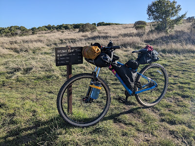
Bolinas Ridge Trail


What is bikepacking? It is basically the same as backpacking except instead of carrying all of your stuff on your back, you carry it on your bike. Your stuff includes a tent (unless you are going to cowboy camp, aka lay out your bedroll under the stars) and sleeping gear at the very least and can include a stove, pots, food, bike tools, extra clothes, electronics and toiletries. So, like I said, pretty much like backpacking. Usually the route consists of more trails than pavement, also like backpacking, but can be on highways, gravel roads, bike paths, logging roads, forest service roads or fire roads. 

Here is Bob, all loaded up and ready for adventure!


How did I find out about this? I have no friends who do this. To be honest, and I am a little embarrassed to admit this, I found it on YouTube. I was looking for ideas for summer hiking/backpacking and I stumbled across this channel where two regular people completed part of the Great Divide Mountain Bike Route (GDMBR) and I thought, "I want to do that!" and I started looking into it. I found a great local route that I could get to without driving and off I went. Of course, before this, I went pretty deep into a YouTube wormhole. You know how that goes. 

The route that I found can be found on Bikepacking.com and is called the North Bay Overnighter. It is an 80 mile route that goes from the Golden Gate Bridge (GGB) through the Marin headlands to Samuel P. Taylor park near Point Reyes and back a different way to the GGB to finish the loop the second day. These are mostly trails that I have run on before, so I felt pretty comfortable with the route-finding aspect of the trip although this also meant that I knew exactly what I was up against in some cases, which was a little bit daunting! 

Day 1: The official route starts and ends at the Anderson parking lot on the Marin side of the GGB. However, since I live in Oakland, I decided to get there by bike rather than driving. I started off by riding my bike from my house to the BART, which I took to the Civic Center station in the city. It was pretty early in the morning and the only people on the street besides me were the homeless, the druggies and the prostitutes. This is not the most beautiful part of the city, let me just say that. From the Civic Center, I rode down to Fort Mason and then went past Chrissy Field to the end of the GGB. I crossed the bridge in the fog and wet and finally got to the official start around 8:00 am with about 9 miles under my belt already. 

Crossing the Golden Gate Bridge

View of the Golden Gate Bridge from the headlands


From there, the route goes up the road to the Coastal trail, and the sun was just starting to break up the fog and I had some really nice views of the bay. I then cruised down the Coastal trail, which is a very gradual downhill, although there were a few rutted areas that made me realize that I had no idea if was best to ride in the rut or try to stay on one of the side lumps, and at one point I heard another bike behind me and I was not sure if I should pull over or get off to the side or...what the rules were! The route goes down, crosses the road and then heads back up Bobcat, which is really just one big mile and a half long uphill and is a trail I have run many times, but have never been able to run the entire uphill without walking a little. However, I rode the bike without stopping the entire time and I was so proud of myself that I stopped at the top for a snack before heading down towards Tennessee Valley. 

From Tennessee Valley parking lot, the trail goes back up the Miwok trail, which was my first experience with the hike-a-bike! Also by now it was actually getting warmer and I shed yet another layer on my way up this hill. After the uphill, Miwok is a nice gradual downhill that crosses highway 1 before going back up towards Dias ridge. Dias was my first true single-track and I had "fun" learning how to manage the hairpin downhill turns, although I did  have one slow speed fall in this section. Side note: the completely packed bike is probably about 50 pounds, which is hard to control on the curves! You live and you learn, I guess. 

Dias Ridge Trail


After going down Dias you get to Muir Beach and this is where I had to break out the GPS. The trail was hard to find, as the route takes you basically up the side of a hill in what looks like someone's backyard, but I think it is just an attempt to not make you ride on the road for that section. However, it is a little strange, as you come out at the top on the road, which you then have to ride on for about a mile and a half before you go back onto the trail again. I was a little afraid of the road as I have driven on it and seen cyclists and it seems a bit scary (it is a windy coastal road) but people were polite and the traffic was still not yet too bad. 

Getting off the road and back on the trail toward Cardiac/Pantoll


The trail takes you to Cardiac and you cross the Dipsea before heading to Pantoll, which is a parking lot, bathroom, water fountain and camping area. Apparently there is hike in/bike in camping here but I was only about 21 miles into the official 40 that I was supposed to do this day, so I kept going. From Pantoll, you ride on the road uphill for about 2 miles; again, this was with cars, but there were also a lot of bikes and the cars were pretty polite. Then came one of my favorite parts of the ride: Ridgecrest Blvd. This road was mostly downhill and is very flowy, with barely any cars AND a view of the ocean for days, and then you go into a redwood forest and it's dark and moist and magical. It is super cool! It was so SO fun. 

Ridgecrest Drive

After four miles, you turn off on the Bolinas Ridge trail, which is dirt but doesn't have too many steep ups or downs and goes on for several miles. However, the very end, when you are headed down toward the turnoff to the camping, is a lot of bumpy downhill, which was quite jarring at times. When you get almost to Point Reyes, you turn off and go to Samuel P. Taylor park, where there is a hike in/bike in campground and for $7 you can put up your tent! I got there around 5 pm, put up my tent, made dinner and then spent a wonderful few hours listening to my audiobook before heading to bed. I did this trip in January and I was the only person in the shared campsite! 

Bolinas Ridge Trail

Samuel P. Taylor hiker/biker camping

Day 2: The next morning I got up early, realized I was out of fuel, drank a cup of cold coffee, strapped on my headlamp and hit the road. Well actually it was a nice flattish paved trail at first, but very soon afterward, I went straight uphill into the fire roads again. Seriously, my first 2 miles were flat, then the next 8 miles were about 3,000+ feet of climbing. Again, I embraced the suck of the hike-a-bike, but I spent a long time wondering when the joy of the downhill was going to come. When the downhill finally came thought, at first it was not very joyful. It was very rocky and rutted and I actually had to push my bike on some of the downhills! 

View from the top of the hike-a-bike near Kent Reservoir


When I got back to the Bolinas Fairfax road, I decided that instead of going into Fairfax and then back up the hill to Tam and then down again to Tennessee valley and then up again to the start line where I would then have to cross the bridge and ride the BART, I would rather skip the extra hills and the public transportation and head back home via the Richmond bridge. So I went through Natalie Coffin park into Ross and from there I took a series of bike paths into Larkspur, where I rode out onto the Richmond Bridge. Once I got to Point Richmond, there was only about a mile of street riding before I got onto the bike path along the bay. A lot of this part of the route was on the San Francisco Bay Trail, which is a trail that goes all the way around the Bay Area. Some of it is on an actual dirt trail and parts of it are on roads and bike paths, but all together I believe there are over 500 miles! 

Larkspur bike path

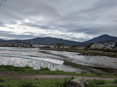
View of the city from Richmond (SF Bay Trail)

Once I got to Emeryville, I had to go back onto the streets to get to Oakland, but I have to say most of them have pretty good bike paths, so it was not too intimidating. However, I was definitely ready to be done and I even briefly considered taking the BART although by this point it would not have saved me any time or even very many miles! To add insult to injury I let Google maps tell me which way to go and it took me right up a hill that I normally try to avoid (MacArthur Ave.) However, avoiding it would have added a mile probably, so maybe in this case it was really half a dozen of one and six of the other. It sure was nice to get back home though and I celebrated by taking off my bike shorts and walking around without pants for a few minutes before making myself something hot to eat. (TMI? Too bad!) 

Thoughts/What I Learned: Sometimes riding on the road can be fun. I need to bring more food next time. I am stronger than I think I am. When riding down hills, lift your butt off the seat unless you want to be sore later. Samuel P. Taylor is very beautiful. Pushing a 50 pound bike up a hill makes my arms feel like noodles. It also makes me VERY hungry. I probably need different shorts (I am wearing hiking shorts over bike shorts). A screw top water bottle is a lot of work (will bring squeeze bottle or hydration bladder on next trip). 

Comments: Bikepacking.com says that this route in 99.9% rideable with a difficulty of 4/10. I would agree with the latter, as is it mostly fire roads and there are not too many rocks or things to avoid, so even a beginner like me can do it. However, 99.9% rideable is perhaps a stretch as I don't know who can ride up the 14% - 20% grade at the beginning of day two. Maybe I am just out of shape, I don't know, but 99.9% would mean that less than a tenth of a mile is not rideable out of the entire 80 miles. 

Total Miles: 98.3
Total Elevation: 11,300 ft.
Total Time: 15 hours

Download the Ride With GPS GPX file here. I get ideas and inspiration from: Bikepacking.comRyan, Chris and his buddy Rob, John and Mira. 

Have you ever gone bikepacking? Tell me about a YouTube or internet wormhole you have found yourself deep in, and how did it turn out? 

2.22.2023

What is a Regular Weekend Anyway?

Thank you to all who commented on my last post. I am taking all of your advice into consideration! However, I am still doing some digging, so if you have not weighed in yet, you can still go here and let me know your thoughts. 

Last weekend was a long one and it gave me the perfect opportunity to get some stuff done and still have fun too! I was thinking about what a regular weekend around here looks like and of course it depends on the weekend, but a regular weekend at home generally looks like this: prepping meals for the next week, laundry, house cleaning, working in the yard, a run (or two), reading, working on the purging project, and meeting up with friends for a hike/run/coffee. However, weekends lately have been a little different! 

Remember my post about being uncomfortable? Since I wrote that post, I have been even more uncomfortable! That ride was about 40 miles; after that was a success, on New Years weekend, I decided to ride to my brother's house in Santa Rosa, which is about 70 miles away from where I live. Before I started, since it was supposed to be a little wet, I got new tires and put them on Bertha. A quick backstory: Bertha is old, maybe even older than me, but I am not really sure, as I have been told that it is rude to ask a lady her age. She is a ten speed, of which maybe only three of the speeds work and her brakes have not been changed the whole time I have had her, which has been about ten years. So she is not really in tip top shape, but she gets the job done. 

The day that I planned on starting, Mother Nature was not having it; you may recall that this was the weekend where we were hit with the bomb cyclone? So I had to wait a day and shorten the ride, but in the end, I started off bright and early on Saturday morning from Richmond point and went across the Richmond bridge for the 2nd time in less than a month. Surprisingly the weather was good, the winds were in my favor and I got through San Rafael with no issues. 

I don't really know (but am learning!) what normal cyclists use for navigation, but I used Google maps and kept my headphone in while riding so that I could hear the directions as I went. Sometimes they are confusing, like when she says, "turn right, then left" but really she means, "stay on the same path" so I did go the wrong way a couple of times since I was not actually looking at the map, but generally it was fairly easy to follow. My route took me through San Rafael, Novato and Petaluma before putting me on Stony Point road, which was 14 miles long and actually went straight to Santa Rosa and almost right to my brother's house. 

Once I arrived there, we took a shake out walk and went for New Years Day pho before relaxing in the hot tub and then in front of a movie with ice cream. Broski and Mrs. Broski always treat me right. 

The next day, I got up early and left as it was supposed to start raining again at 11 am and I wanted none of that. I had gear and everything but one of my fears is slipping on the wet street and falling in the middle of traffic, or even just on the ground on a hard bike path or street. Not to say I will never ride in the rain but for now I would like to avoid it when I can. It was great riding back along Stony Point with the sun rising and no cars on the road. 

As I said above, my route generally followed frontage or access roads near highway 101, but often took me into the downtown areas of the towns I went through and I will not lie, although I have been to and driven through these towns before, I had never been to some of their downtowns and they are very cute. For example, Petaluma has a nice old town downtown with cute shops and everything! I will have to come back to explore more as I was trying to outrun the rain, but who knew! Petaluma also had a bathroom that was open, which I was very grateful for, as I had made a pitstop in the bushes the day before. 

I got back to Richmond only slightly damp and it actually started raining shortly after that. Score. What are my takeaways? I learned that I am not a fan of padded bike shorts. So, when I say uncomfortable, I really do mean physically this time. I nicknamed them my "diaper" and have a few TMI things to tell you about this. First of all, did you know that you are supposed to wear them without underwear? I can't tell you how glad I am to get to my destination and take off the shorts and put on underwear. It's my new favorite thing. I learned that I need new brakes, which I have since bought and not yet installed. 

One of the most useful things I have learned on this adventure but also in life, is that you don't need special or fancy equipment to start a new adventure. You just need to try it with what you have! I put a change of clothes and some tools in a dry bag, strapped it to the back of the bike with a bungee and used that as my "paniers," I clearly do not have a state of the art bike, I wear old running shoes (another use rather than gardening!) and I wear whatever is comfortable. I get passed by sleek riders, dressed in fancy matching spandex with $16,000 bikes made of air, as I huff and puff on my 57 pound bike up a hill with my lowest of three gears. But you know what, I arrive home tired and happy and proud of myself for not letting any of that stop me. Not to get on a tangent here, but the same goes for everything! Don't let the lack of gear or the lack of experience or the fear of looking silly hold you back. 

Total miles: 105 (54 + 51)
Time taken:  10 hours (5.5 + 4.5)
Bridges crossed: 1, but I crossed it twice (Richmond)
Modes of transport: 2 (car to Richmond, bike)
Map of my trip: https://caltopo.com/m/E803B 

What does your regular weekend look like? What does your out of the box/adventure weekend look like? 

1.26.2023

Everybody Meet Bob, Bob Meet Everybody

I mentioned that I got a new mountain bike. I have christened him Bob. As you know, the road bike is Bertha and it just seemed to go together. I have never had a mountain bike before. I have been mountain biking once in Bolivia, when I rode on the World's Most Dangerous Road, which is a downhill ride from about 4,000 meters (13,200 feet) to 1,000 meters (3,300 feet) and is a combination of paved road, dirt road and single track. 

This is Bob! 

In the last several years, I have done a lot more road biking. It has mostly been commuting but I have also added in a few longer rides and have really enjoyed myself. However, I am a woman of the woods at heart so I thought it was time to adventure out to the dirt. First I had to figure out what kind of bike I needed. Have you ever tried to buy a bike? There are hard tail, gravel bikes, bikes with no shocks and bikes with extra shocks. There are aluminum and carbon frames, there are different sizes and shapes and...man, there are so many different options and many of them are expensive! 

What I ultimately wanted was something I could take bikepacking; this is like backpacking but on a bike. You load up the bike and ride off into the woods for a few days and camp along the way. If you know me at all, you know this is right up my alley! So I chose a hardtail bike and I put a price alert on it and when the alert got triggered, I bit the bullet and bought it. Then it arrived in a big box and I had to put it together myself. I know a little from having the road bike but most of this  is new to me. 

So, basically the point of all of this backstory is that I have been having fun. Like I said in this post, we so often get so used to doing things that we know how to do, but this has given me so many different learning experiences! Have they all been fun? No. I luckily put my pedals on the right sides, but did not crank them down so that they would stay on all the time. I already had to fix the shifter and I now am on a first name basis with the local bike shop. 

BUT! Bob and I went out for our first ride this week. The trails are still a tad wet, but oh my gosh, it was SO FUN! I felt like a little kid again. I have to ride up a big hill to get from my house to the trailhead and then I had a few big hills on the trails and they were hard, but I did it! I had to go down rocky and rooted trails and I definitely tested out my brakes, but flying down the hill when you have a more smooth surface is such a thrill. 

I feel like a highschool girl with her first crush! He is so cute! I am in love. K + B forever! Like a highschool girl though, I am sure the sheen will wear off and reality will hit me, but for right now I am on cloud nine! 

Have you ever mountain biked? If so, I need tips! What is the hardest thing you have had to put together yourself (and how many screws did you have left over at the end)? 

12.20.2022

On Being Uncomfortable

As adults, we become fairly stuck in our ways at times, doing the same routine or same tasks over and over. Having kids definitely gives people a new outlook, new tasks to do, new people to meet. For example, for the last couple of years I have been helping a single mom friend shuttle the kids to soccer and lacrosse practice and games. Not only have I learned about pickup and drop off (did you know that only a couple of the parents get out of the car? I always get out of the car. Am I doing that wrong?), but I have been learning how to play lacrosse (this is not a sport we had available when I was a kid). I am learning how to listen to and to give advice to kids; I am learning some bad (but very fun) dad jokes. 

Aside from that though, what do we do to put ourselves out of our comfort zone? Last weekend I took a bike ride with Bertha (that's my bike). This may seem easy enough, but my plan was to take my old bike all the way around the bay. Here is my CalTopo map. This would mean crossing two bridges and going into towns that usually I only fly by on the freeway. It would mean riding in the street, sometimes on roads with little shoulder and across two bridges with various rules and strange entry points. It would mean not knowing where I could use the bathroom or whether or not I needed to lock up my bike or where I could lock it up. It would mean riding further than I ever had before. It would mean being out of the house for an unknown period of time, in the cold and the wind. My bike could break down; I could get a flat; I could get lost; I could encounter all manner of things. 

But. I could have fun, learn something I did not know yet, stretch my ability and see new things. Which is what I did. I started at my house and rode to a bar in uptown Oakland to watch the World Cup final. After watching Argentina get a much deserved win, I got back on the bike and started riding toward the Richmond bridge. Luckily, there is a bike path that goes all the way from Emeryville to Richmond, which is about 10 miles long and sticks to the shoreline so there would not be too many cars to contend with. 

I followed that for about 10 miles and then had to go on the streets to get to Point Richmond, which is usually easy to get through. However, they were doing construction and there was a detour and instead of going on a flat street through downtown I went nearer to the coast and the hills and got quite an unexpected work out. Once I recovered from that, I went toward the bridge, but I didn't realize that when it said right turn it meant right after the street, not ON the street, so I almost went on a freeway entrance until a guy rolled down his window and told me that the bike path was just up the street. Oops! 

Bay Area bikeways

Next was the approach to the bridge and then a four mile stretch on the bridge, which always seems flat when I am driving on it, but I swear was uphill the whole way on the bike. Plus there was a cross wind that did not make it any easier. This was the point that I decided that my 50 mile circumnavigation of the whole bay may be a little ambitious and I should start thinking of a plan B. Luckily, depending on how long you want to wait, there are three ferry options that go into San Francisco as well as several bus options. So I got off the Richmond bridge and cruised into Larkspur where there is a ferry. Unfortunately, the next ferry came in about an hour and a half, but I did not want to just sit around and wait, so I decided to press on to Sausalito where I could catch the ferry from there if I hurried. 

Approaching the bridge

Richmond Bridge

Of course from Larkspur to Sausalito there were about 17 different turns and it did take me a while to make sure I was going the right way. Also when I got on the bike path that goes into Sausalito, which I have run on before, it was a lot more miles than I remember to get from there to the ferry. Of course the headwind did not help and I was passed several times by cyclists with large strong thighs, which really made me realize that I need to train more for this sport. However, it was a beautiful sunny day and there were people out enjoying it and it really was a great day to be alive. 

In Sausalito, I literally walked onto the ferry and it left, so if I would have been 5 minutes later I would have missed it and had to either wait another couple of hours or climbed the dreaded hill and crossed the Golden Gate bridge. Instead I had a great ride, ate a snack, enjoyed the view of the city and Alcatraz (if you have never taken this ferry, I highly recommend it. It is much cheaper than a proper bay cruise) and the all of the bridges. 

From San Francisco, I took the BART back to Oakland where I had about a four mile ride to get back home. I will admit, but this time I was super hungry despite my snack on the boat, but my butt was definitely not as sore as I thought it might be after such a long ride. This actually is now my longest ride ever! 

So, after this long story, what is my point, you are asking!? I would say the moral of the story is thus: first of all, you can teach an old dog new tricks...just kidding. Seriously, get out and try new things. Maybe it is embarrassing or unusual or uncomfortable or HARD, but you won't know until you try it and if you hate it you don't have to do it again, because you know what? You are an adult! However, I have found that many of those hard or uncomfortable things often become my favorite new thing to do.  Did I learn from this one? Yes. Did I have fun? Most certainly. Was it hard? You bet it was. Will I take another long bike ride? Definitely.

Total miles: 42
Time taken: 4 hours
Bridges crossed: 1 (Richmond)
Modes of transport: 3 (bike, boat, train)
Map of my trip: https://caltopo.com/m/G96UB 

What uncomfortable thing have you done lately? Have you ever taken a long bike ride? If so, what tips can you impart for my next ride? 

10.12.2015

It's a Wild Ride

It's 4:49 a.m. My alarm goes off and I hop off of the couch, where I have been sitting and reading. I wash my breakfast dishes, grab my lunch and use the bathroom one last time and then I put on my helmet and grab my bike and my backpack and walk out the door.

It's about 2 miles from my house to the train station. Luckily, in the morning, it's mostly downhill. I put on my bike light, hike up one leg of my pants and start pedaling. You never know what you are going to see on the streets of Oakland at 5 a.m. There are not too many cars, which is good because that means I can buzz through most of the intersections without slowing down too much. There are sometimes people, but they are mostly like me, heading to work in the dark of the night.

Except for one corner which is near the train station. This corner is a bit different that the others. Women hang around in short skirts; men in trucks slow to a crawl as they pass. It's usually pretty quiet though; I pedal through with no problems.

I reach the train station in about 7 minutes. I constantly try to break the 7 minute time and have only done it once. It all depends on how I hit the traffic lights and how many cars there are that I have to avoid. I get there around 5:07, lock up my bike and hop on the train to work.

In the afternoon, the same journey takes about 12 minutes. From the station, I have to ride uphill and generally its around 4 or 5 pm. I have to stop at every intersection, sometimes for 2 or 3 minutes. There are cars to avoid, as well as people, broken glass, a lone shoe and a condom. It's hot and the traffic is busy and I swerve around old ladies and kids on skateboards. It's a whole different world. I can see everything.

I get home, hop off my bike and push it into my living room, where it lives. I do everything in reverse: walk in the door, backpack off, helmet off, put my lunch in the sink and use the bathroom one more time.

Note: I have been commuting by bike to the train station for a few months now and am really loving the view I am getting of the world this way. Plus a little extra exercise using different muscles never hurts!

How do you get to work? Do you ever walk or ride a bike? What interesting things have you seen while cycling? 

5.10.2013

Beer, Bikes and Busted Plans

{1} Why is it the week I decide to avoid sugar is the week that...I go out to dinner with my brother (which I only do about once a month), my friend's band is playing at a bar in my neighborhood, the ladies at work get together for happy hour, I am meeting a friend for a birthday dinner (two times eating out in one week!) and it's Mother's Day Brunch. When it rain's it pours, I guess.

{2} I went to see my friend's band on Wednesday and I rode my bike to the show. I am no bike expert, let me tell you. I barely know how to shift gears. Why does it always seem like every time I shift it gets harder? It never gets easier, I swear! Downshift, upshift...either way, it keeps getting harder. So I was riding the bike back home when I shifted and the chain fell off and got tangled up in the round thingy, which I googled, and found out it's called a cassette. I had to walk the rest of the way home.

{3} I was supposed to go to a music festival this weekend, but then my friend flaked out so we decided to sell our tickets and I made other plans with other people for the weekend. But then nobody wanted to buy them and I've been placing ads on Craigslist and dealing with a lot of flaky people and I am getting annoyed. This is why I don't change plans; it gets aggravating, scrambling around at the last minute trying to coordinate things, changing plans with everybody, not knowing what your actual plans will be, and losing money on top of all of it.

{4} My roommate got a dog. That's really all I have to say about that. No really, it's cute; it's a puppy; it pooped on the floor today. What else is there to say, really?

{5} I have this race tomorrow with Broski. It will be his first 30k and his longest run ever! By the way, I think he's finally come to terms with the fact that the trail "half marathons" are not always 13.1 miles.


What's going on in your life? Any fun plans for the weekend? Do you know anything about bikes?

3.18.2013

Step Back!

Today marks the start of the 15th week of Boston training. For those of you who have followed an 18 week training schedule, you know what that means. It means that this week is the highest mileage week in the training schedule. On the schedule this week is my last 20 miler, and a total of 58 miles for the week. I have to say, I will be glad when it is over. Not that I love the taper weeks, but it will be nice to be able to go for a bike ride, or a hike or a kickboxing class, and not have to worry about it cutting into precious running time.

Speaking of a bike ride, last week was a step back week, which means that my long run was only 12 miles and the total mileage for the week was a lot lower than this upcoming week. This did give me a little bit more freedom and I ran with it (ha! no pun intended).

On Sunday, I ran a 5k for Jill's Virtual St Patrick's Day run. It was a great day for it and I gave it my all, finishing in 21:46.


Then I bought a few more accessories for the bike (U-lock and cushy seat cover), I took it out for it's first REAL ride. I have been using it to run errands, like going to the grocery store or library, which are only about a mile from my house. There is one big hill between my house and the grocery store though and I can ride all the way up it one way but coming back it is steeper on that side and I have had to walk it up.

So I was pretty nervous about attempting a longer bike ride. There were a few things I worried about.

(1) That I would get hit by a car. Other people on the road don't always pay attention! I know this, because as a runner, I have come VERY close to being hit a few times. I always feel a bit smaller when a bus comes within a few inches of me. I feel very small in fact.

(2) That I would have to walk up all the hills. Ah, failure, how we fear thee.

(3) That my butt would be on fire by mile 4. Hence the new cushy seat cover.

bike ready
The Beast, with a new hat for the seat and a fancy St. Patty's day U-lock.

As a runner, we have the same issues. Chafe, pains, fear of failure, and feelings of fragility. So I am used to them. So I said to myself that it is no different than what I am used to, and I got to it. My running friend broke her toe and she asked me if I wanted to ride to a pub that was about 16 miles from my house. Why not? You only live once. YOLO!

It went well. In fact, it went better than I thought it would. I did NOT get run over. We started in Oakland, going through the town for about 7 miles before we got to the SF Bay Trail, where we stayed until we reached Richmond. We stopped for a St. Patrick's day beer at a local pub and then we headed back. We tackled one big hill on the way back and I didn't get off the bike once. The cushioned butt pad was fabulous!

Point Richmond
Point Richmond

When I got back to Oakland, I had a humongous burrito and then headed for my final two miles to get home. Unfortunately, the last mile has another fairly steep hill (0 ft - 200 ft in about a half a mile) and I just couldn't do it. These legs were toast and they had really started to realize it when I sat down to eat the burrito.  But I made it. So that's one ride over.

See that hill at the very end? It was brutal!

Total miles: 41.4
Average speed: 11.3 mph

I am pretty excited, because I have always thought I would like to try a triathlon, but it's the biking that was my biggest fear. Now I just need to get over this week's "hill" in my Boston Training (and the Marathon itself) and then I can work on getting better at my biking skills! 

What did you do for St. Patrick's Day? Have you ever done a long bike ride? How do you combat butt soreness?

3.07.2013

Wheels on Fire

I got a bike. It is not a new bike. In fact, from what I can tell from the interwebs, it is a circa 1980 road bike. It looks like this:


That is not the actual bike. I found that on the Google. So you can't really see, but the shifters are on the frame, rather than on the handles.


Weird right? Okay, so I have to admit, I don't know anything much about bicycles. I think the last bike I had was the kind with the tassels on the handlebars that you pushed the pedals backwards in order to brake. It may have even had a banana seat. But I have rented or borrowed a few grown up bikes and have ridden a bit, even in the city. I know, I am a big girl now. However, I have never had a bike with the shifters on the frame.

Since I have a bike now, I decided to get prepared. I have a helmet and a bike lock of course. I also got a patch kit, a tube and a really cool 19-in-1 tool that I have absolutely no idea how to use. It looks really fun though. I also got a red blinky light for the back,  another blinky light for the front AND just for fun, some LED lights you put in the tire valve and it makes fun colors or shapes when you ride.

bike kit

I bet you are wondering if I am planning to ride the bike or just buy ridiculous accessories for it. I am strongly considering the latter. No, I am kidding. I actually rode it once. A whole mile and a half, in the dark, to go and drop off my library book. I didn't fall or get run over, so that's a start. However, there is a very big hill between my house and the library and I had to walk the bike up it because (a) I couldn't lean down to shift the gears, pedal AND hold the handlebars at the same time very well, and (b) My legs were like jello.

It seems we have our work cut out for us.

*title inspired by this song

What have you had to learn/relearn as an adult? Was it hard? Do you ride a bike?

8.19.2008

Titty Caca

Haha, I can actually say that without feeling like I am disrespectful! We are near Lake Titicaca, in Puno, Peru. According to the Peruvians, they got the Titi and Bolivia got the Caca. The funny thing is that Bolivia actually has the more beautiful side of the lake. There are a bunch of mountains surrounding it which are more than 6000 meters high (19000 Feet) and are covered in snow. It is a very nice place to be.

First we went to the WORLDS MOST DANGEROUS ROAD, which is near La Paz, in Bolivia. We survived! We mountain biked down from about 4000 meters to about 1000 meters in about 4 or 5 hours. Half of it was paved and half dirt, but the whole thing was a lot of fun! Next we went to Copacabana and the Isla de Sol, which is supposed to be where the Inca civilization began.

Next we headed to Peru, where we visited Arequipa, which was built in the 1500s and is quite beautiful with a huge church on the main square which occupies the whole block. We also visited the Convent of Santa Catalina which occupies a whole city block and is where the rich Spanish families would send their daughters (for a hefty fee of course). The picture above is one of Santa Catarina. It was beautiful!
From Arequipa, we came to Puno, where we are now. Yesterday we went on a tour of the floating islands and got to spend the night in the house of an indigenous person as well as dressing up in local dress and going to a local fiesta (pictures to come later - it was great!).
Tomorrow we head to Cuzco and then we will tackle Machu Pichu!! I am very excited about this although the altitude has been a little rough at times!

10.11.2006

My Life Goes Downhill

I lifted up my leg, swung it around and over the seat, closed my eyes and started to pedal, all the while praying to god that I would not fall....

The last time I rode a bike in San Francisco was with my friend Omar, who knew all the ups and downs, where to go and how to get there. And that time that I rode with him ended in disaster. Just as we were pulling back into the street where he lived, I slipped on the MUNI (train) track and fell down right in the middle of the street. I narrowly missed being hit by a car and escaped with only a scraped up face and a bruised shoulder.

So this time I gingerly got back on the bike and readied myself (mentally and physically) to go on a bike ride around the city once again. And this time it was by myself. I don't even know how to ride a bike in the city, really. I mean, what am I? Am I a car? Am I a pedestrian? No, I am a bike. But what are the rules for a bike? Can you google them? Well, I did not google them; I just hopped on the bike and got in the right lane of traffic and kept my fingers crossed that nothing too large would ram into me as I was frantically pedalling down the (seemingly) busiest street in town. When I had to turn left, I just got in front of all the fast moving cars and made them wait while I got across the 6 lane, 4 way stop.

I need a blinker! I need a horn! I need a gas pedal. San Francisco is not well known for having many flat areas. Nope, San Francisco is mainly made up of hills, which is cool when you are standing at the top of one, looking down at the beautiful view. But when you are trying to GET to the top so you can look at the beautiful view, it is a different story all together. Why does a bike have so many gears? And which gear makes it so I don't actually have to pedal up the hill? Isn't there one where you can just set it and the bike coasts up the hill on its own? If there is, I have not found it. I put the bike in the lowest gear possible and pedaled so fast I thought my legs were going to spin off my body and onto the street below and STILL it took me (what seemed like) 30 minutes to get to the top of the hill.

So then wouldn't it make sense that if you are at the top, there is nowhere to go but down? Sure, if you were anywhere else but "the hilly city by the bay". Somehow, however, here in San Francisco it seems to be uphill both ways.